You are here: Home > Network List > TA - USArray Transportable Network (new EarthScope stations) Stations List
> Station O52A Adamsville, OH, USA > Earthquake Result Viewer
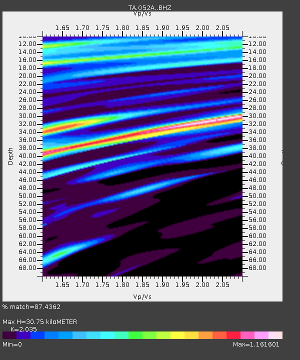
O52A Adamsville, OH, USA - Earthquake Result Viewer
| Earthquake location: |
Southern East Pacific Rise |
| Earthquake latitude/longitude: |
-32.7/-111.7 |
| Earthquake time(UTC): |
2014/10/10 (283) 17:12:25 GMT |
| Earthquake Depth: |
10 km |
| Earthquake Magnitude: |
5.2 MW |
| Earthquake Catalog/Contributor: |
ISC/ISC |
|
| Network: |
TA USArray Transportable Network (new EarthScope stations) |
| Station: |
O52A Adamsville, OH, USA |
| Lat/Lon: |
40.12 N/81.84 W |
| Elevation: |
331 m |
|
| Distance: |
77.6 deg |
| Az: |
23.047 deg |
| Baz: |
205.495 deg |
| Ray Param: |
0.050240766 |
| Estimated Moho Depth: |
30.75 km |
| Estimated Crust Vp/Vs: |
2.04 |
| Assumed Crust Vp: |
6.483 km/s |
| Estimated Crust Vs: |
3.186 km/s |
| Estimated Crust Poisson's Ratio: |
0.34 |
|
| Radial Match: |
87.4362 % |
| Radial Bump: |
400 |
| Transverse Match: |
73.915245 % |
| Transverse Bump: |
400 |
| SOD ConfigId: |
3390531 |
| Insert Time: |
2019-04-14 11:24:00.281 +0000 |
| GWidth: |
2.5 |
| Max Bumps: |
400 |
| Tol: |
0.001 |
|

Signal To Noise
| Channel | StoN | STA | LTA |
| TA:O52A: :BHZ:20141010T17:23:49.97502Z | 0.6879887 | 1.9182933E-7 | 2.7882626E-7 |
| TA:O52A: :BHN:20141010T17:23:49.97502Z | 0.7542535 | 2.1640946E-7 | 2.8691872E-7 |
| TA:O52A: :BHE:20141010T17:23:49.97502Z | 2.1751683 | 5.4894815E-7 | 2.5237043E-7 |
| Arrivals |
| Ps | 5.0 SECOND |
| PpPs | 14 SECOND |
| PsPs/PpSs | 19 SECOND |


