You are here: Home > Network List > WU - The Southern Ontario Seismic Network Stations List
> Station PLIO Pelee Island, Stone Alvar Conservation Area, Ontario, Canad > Earthquake Result Viewer
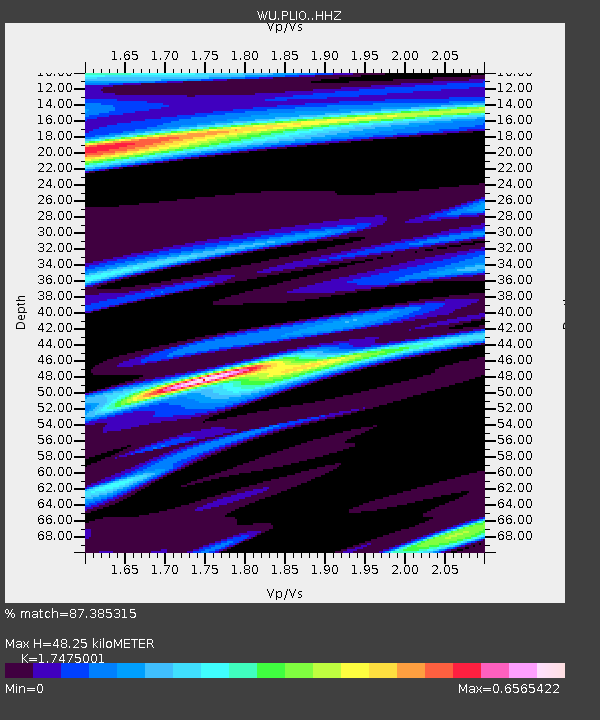
PLIO Pelee Island, Stone Alvar Conservation Area, Ontario, Canad - Earthquake Result Viewer
| Earthquake location: |
Southern East Pacific Rise |
| Earthquake latitude/longitude: |
-32.7/-111.7 |
| Earthquake time(UTC): |
2014/10/10 (283) 17:12:25 GMT |
| Earthquake Depth: |
10 km |
| Earthquake Magnitude: |
5.2 MW |
| Earthquake Catalog/Contributor: |
ISC/ISC |
|
| Network: |
WU The Southern Ontario Seismic Network |
| Station: |
PLIO Pelee Island, Stone Alvar Conservation Area, Ontario, Canad |
| Lat/Lon: |
41.75 N/82.63 W |
| Elevation: |
143 m |
|
| Distance: |
78.8 deg |
| Az: |
21.784 deg |
| Baz: |
204.719 deg |
| Ray Param: |
0.049407862 |
| Estimated Moho Depth: |
48.25 km |
| Estimated Crust Vp/Vs: |
1.75 |
| Assumed Crust Vp: |
6.498 km/s |
| Estimated Crust Vs: |
3.718 km/s |
| Estimated Crust Poisson's Ratio: |
0.26 |
|
| Radial Match: |
87.385315 % |
| Radial Bump: |
399 |
| Transverse Match: |
52.702553 % |
| Transverse Bump: |
400 |
| SOD ConfigId: |
3390531 |
| Insert Time: |
2019-04-14 11:25:24.482 +0000 |
| GWidth: |
2.5 |
| Max Bumps: |
400 |
| Tol: |
0.001 |
|

Signal To Noise
| Channel | StoN | STA | LTA |
| WU:PLIO: :HHZ:20141010T17:23:56.730024Z | 0.9439725 | 3.7396492E-7 | 3.961608E-7 |
| WU:PLIO: :HHN:20141010T17:23:56.730024Z | 1.2615324 | 3.462884E-7 | 2.744982E-7 |
| WU:PLIO: :HHE:20141010T17:23:56.730024Z | 0.82336307 | 2.3127139E-7 | 2.8088627E-7 |
| Arrivals |
| Ps | 5.7 SECOND |
| PpPs | 20 SECOND |
| PsPs/PpSs | 26 SECOND |


