You are here: Home > Network List > II - Global Seismograph Network (GSN - IRIS/IDA) Stations List
> Station EFI Mount Kent, East Falkland Island > Earthquake Result Viewer
EFI Mount Kent, East Falkland Island - Earthquake Result Viewer
| Earthquake location: |
Near Coast Of Peru |
| Earthquake latitude/longitude: |
-13.4/-76.6 |
| Earthquake time(UTC): |
2007/08/15 (227) 23:40:57 GMT |
| Earthquake Depth: |
39 km |
| Earthquake Magnitude: |
6.7 MB, 7.9 MS, 8.0 MW, 7.5 ME |
| Earthquake Catalog/Contributor: |
WHDF/NEIC |
|
| Network: |
II Global Seismograph Network (GSN - IRIS/IDA) |
| Station: |
EFI Mount Kent, East Falkland Island |
| Lat/Lon: |
51.68 S/58.06 W |
| Elevation: |
110 m |
|
| Distance: |
41.0 deg |
| Az: |
162.441 deg |
| Baz: |
331.868 deg |
| Ray Param: |
0.073966816 |
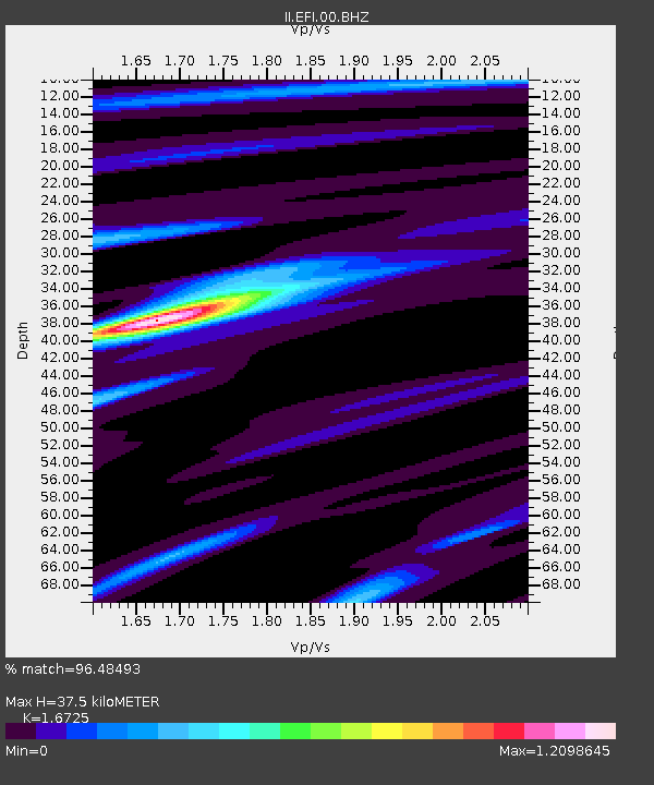
| Estimated Moho Depth: |
37.5 km |
| Estimated Crust Vp/Vs: |
1.67 |
| Assumed Crust Vp: |
6.472 km/s |
| Estimated Crust Vs: |
3.87 km/s |
| Estimated Crust Poisson's Ratio: |
0.22 |
|
| Radial Match: |
96.48493 % |
| Radial Bump: |
287 |
| Transverse Match: |
88.12819 % |
| Transverse Bump: |
400 |
| SOD ConfigId: |
590571 |
| Insert Time: |
2013-09-26 13:45:24.810 +0000 |
| GWidth: |
2.5 |
| Max Bumps: |
400 |
| Tol: |
0.001 |
|
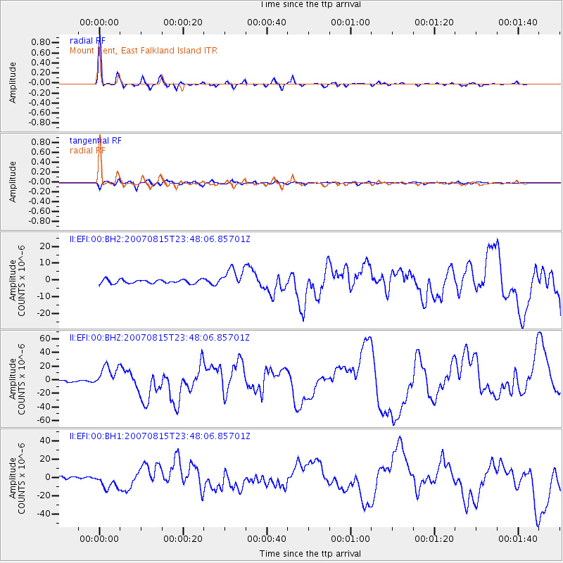
Signal To Noise
| Channel | StoN | STA | LTA |
| II:EFI:00:BHZ:20070815T23:48:06.85701Z | 9.409014 | 1.6924632E-5 | 1.7987678E-6 |
| II:EFI:00:BH1:20070815T23:48:06.85701Z | 5.858019 | 9.084071E-6 | 1.5507071E-6 |
| II:EFI:00:BH2:20070815T23:48:06.85701Z | 5.170628 | 5.8894034E-6 | 1.1390113E-6 |
| Arrivals |
| Ps | 4.2 SECOND |
| PpPs | 14 SECOND |
| PsPs/PpSs | 19 SECOND |


