You are here: Home > Network List > IU - Global Seismograph Network (GSN - IRIS/USGS) Stations List
> Station RSSD Black Hills, South Dakota, USA > Earthquake Result Viewer
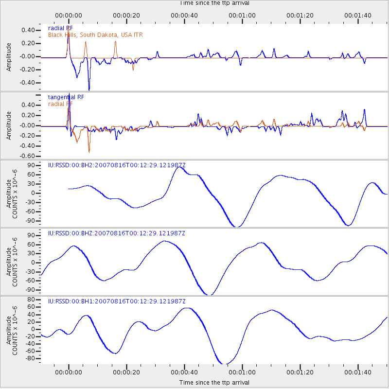
RSSD Black Hills, South Dakota, USA - Earthquake Result Viewer
*The percent match for this event was below the threshold and hence no stack was calculated.
| Earthquake location: |
Near Coast Of Peru |
| Earthquake latitude/longitude: |
-13.3/-76.5 |
| Earthquake time(UTC): |
2007/08/16 (228) 00:02:41 GMT |
| Earthquake Depth: |
40 km |
| Earthquake Magnitude: |
5.6 MB |
| Earthquake Catalog/Contributor: |
WHDF/NEIC |
|
| Network: |
IU Global Seismograph Network (GSN - IRIS/USGS) |
| Station: |
RSSD Black Hills, South Dakota, USA |
| Lat/Lon: |
44.12 N/104.04 W |
| Elevation: |
2060 m |
|
| Distance: |
62.4 deg |
| Az: |
337.917 deg |
| Baz: |
149.452 deg |
| Ray Param: |
$rayparam |
*The percent match for this event was below the threshold and hence was not used in the summary stack. |
|
| Radial Match: |
83.67292 % |
| Radial Bump: |
354 |
| Transverse Match: |
72.23115 % |
| Transverse Bump: |
244 |
| SOD ConfigId: |
590571 |
| Insert Time: |
2013-09-26 13:47:21.318 +0000 |
| GWidth: |
2.5 |
| Max Bumps: |
400 |
| Tol: |
0.001 |
|
Signal To Noise
| Channel | StoN | STA | LTA |
| IU:RSSD:00:BHZ:20070816T00:12:29.121987Z | 2.801098 | 5.8914906E-5 | 2.1032789E-5 |
| IU:RSSD:00:BH1:20070816T00:12:29.121987Z | 0.87422925 | 1.7892888E-5 | 2.0467045E-5 |
| IU:RSSD:00:BH2:20070816T00:12:29.121987Z | 0.60215753 | 1.472095E-5 | 2.4447008E-5 |
| Arrivals |
| Ps | |
| PpPs | |
| PsPs/PpSs | |


