You are here: Home > Network List > KZ - Kazakhstan Network Stations List
> Station KUR21 Cross-array, Kurchatov, Kazakstan > Earthquake Result Viewer
KUR21 Cross-array, Kurchatov, Kazakstan - Earthquake Result Viewer
| Earthquake location: |
Solomon Islands |
| Earthquake latitude/longitude: |
-9.8/159.5 |
| Earthquake time(UTC): |
2007/08/16 (228) 08:39:27 GMT |
| Earthquake Depth: |
10 km |
| Earthquake Magnitude: |
6.1 MB, 6.7 MS, 6.4 MW |
| Earthquake Catalog/Contributor: |
WHDF/NEIC |
|
| Network: |
KZ Kazakhstan Network |
| Station: |
KUR21 Cross-array, Kurchatov, Kazakstan |
| Lat/Lon: |
50.62 N/78.53 E |
| Elevation: |
200 m |
|
| Distance: |
91.8 deg |
| Az: |
320.998 deg |
| Baz: |
103.17 deg |
| Ray Param: |
0.041550983 |
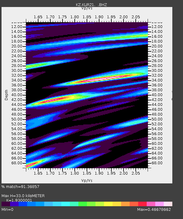
| Estimated Moho Depth: |
33.0 km |
| Estimated Crust Vp/Vs: |
1.93 |
| Assumed Crust Vp: |
6.552 km/s |
| Estimated Crust Vs: |
3.395 km/s |
| Estimated Crust Poisson's Ratio: |
0.32 |
|
| Radial Match: |
91.36857 % |
| Radial Bump: |
400 |
| Transverse Match: |
89.70057 % |
| Transverse Bump: |
385 |
| SOD ConfigId: |
590571 |
| Insert Time: |
2013-09-26 13:52:51.644 +0000 |
| GWidth: |
2.5 |
| Max Bumps: |
400 |
| Tol: |
0.001 |
|

Signal To Noise
| Channel | StoN | STA | LTA |
| KZ:KUR21: :BHZ:20070816T08:52:04.075027Z | 10.075083 | 5.8185196E-7 | 5.775158E-8 |
| KZ:KUR21: :BH1:20070816T08:52:04.075027Z | 4.946748 | 1.7394885E-7 | 3.5164287E-8 |
| KZ:KUR21: :BH2:20070816T08:52:04.075027Z | 1.6261795 | 8.9770495E-8 | 5.5203316E-8 |
| Arrivals |
| Ps | 4.8 SECOND |
| PpPs | 14 SECOND |
| PsPs/PpSs | 19 SECOND |


