You are here: Home > Network List > ZW13 - Locating North Texas Earthquakes Stations List
> Station AZWR Azle B4 > Earthquake Result Viewer
AZWR Azle B4 - Earthquake Result Viewer
| Earthquake location: |
Southern East Pacific Rise |
| Earthquake latitude/longitude: |
-32.7/-111.7 |
| Earthquake time(UTC): |
2014/10/10 (283) 17:12:25 GMT |
| Earthquake Depth: |
10 km |
| Earthquake Magnitude: |
5.2 MW |
| Earthquake Catalog/Contributor: |
ISC/ISC |
|
| Network: |
ZW Locating North Texas Earthquakes |
| Station: |
AZWR Azle B4 |
| Lat/Lon: |
32.81 N/98.31 W |
| Elevation: |
381 m |
|
| Distance: |
66.4 deg |
| Az: |
12.322 deg |
| Baz: |
192.337 deg |
| Ray Param: |
0.05765401 |
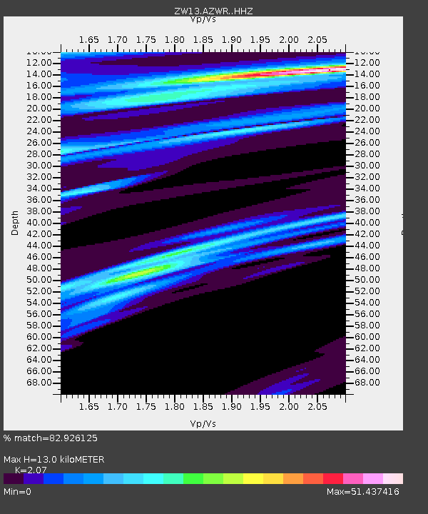
| Estimated Moho Depth: |
13.0 km |
| Estimated Crust Vp/Vs: |
2.07 |
| Assumed Crust Vp: |
6.426 km/s |
| Estimated Crust Vs: |
3.104 km/s |
| Estimated Crust Poisson's Ratio: |
0.35 |
|
| Radial Match: |
82.926125 % |
| Radial Bump: |
258 |
| Transverse Match: |
54.1898 % |
| Transverse Bump: |
301 |
| SOD ConfigId: |
3390531 |
| Insert Time: |
2019-04-14 11:26:48.495 +0000 |
| GWidth: |
2.5 |
| Max Bumps: |
400 |
| Tol: |
0.001 |
|

Signal To Noise
| Channel | StoN | STA | LTA |
| ZW:AZWR: :HHZ:20141010T17:22:43.119978Z | 1.3734748 | 2.2130463E-7 | 1.6112755E-7 |
| ZW:AZWR: :HHN:20141010T17:22:43.119978Z | 2.3628478 | 1.071669E-5 | 4.5354973E-6 |
| ZW:AZWR: :HHE:20141010T17:22:43.119978Z | 2.1424322 | 4.7226736E-6 | 2.2043516E-6 |
| Arrivals |
| Ps | 2.2 SECOND |
| PpPs | 6.0 SECOND |
| PsPs/PpSs | 8.2 SECOND |


