You are here: Home > Network List > IU - Global Seismograph Network (GSN - IRIS/USGS) Stations List
> Station RSSD Black Hills, South Dakota, USA > Earthquake Result Viewer
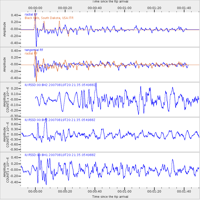
RSSD Black Hills, South Dakota, USA - Earthquake Result Viewer
*The percent match for this event was below the threshold and hence no stack was calculated.
| Earthquake location: |
Near Coast Of Peru |
| Earthquake latitude/longitude: |
-13.6/-76.5 |
| Earthquake time(UTC): |
2007/08/19 (231) 20:11:44 GMT |
| Earthquake Depth: |
35 km |
| Earthquake Magnitude: |
5.6 MW, 5.5 MB, 5.7 ML |
| Earthquake Catalog/Contributor: |
NEIC PDE/NEIC PDE-M |
|
| Network: |
IU Global Seismograph Network (GSN - IRIS/USGS) |
| Station: |
RSSD Black Hills, South Dakota, USA |
| Lat/Lon: |
44.12 N/104.04 W |
| Elevation: |
2060 m |
|
| Distance: |
62.7 deg |
| Az: |
337.996 deg |
| Baz: |
149.619 deg |
| Ray Param: |
$rayparam |
*The percent match for this event was below the threshold and hence was not used in the summary stack. |
|
| Radial Match: |
65.46803 % |
| Radial Bump: |
400 |
| Transverse Match: |
56.390484 % |
| Transverse Bump: |
400 |
| SOD ConfigId: |
590571 |
| Insert Time: |
2013-09-26 14:06:16.489 +0000 |
| GWidth: |
2.5 |
| Max Bumps: |
400 |
| Tol: |
0.001 |
|
Signal To Noise
| Channel | StoN | STA | LTA |
| IU:RSSD:00:BHZ:20070819T20:21:35.054988Z | 2.7157078 | 2.7626953E-7 | 1.01730215E-7 |
| IU:RSSD:00:BH1:20070819T20:21:35.054988Z | 2.4746733 | 2.209079E-7 | 8.92675E-8 |
| IU:RSSD:00:BH2:20070819T20:21:35.054988Z | 1.5178516 | 1.14097354E-7 | 7.51703E-8 |
| Arrivals |
| Ps | |
| PpPs | |
| PsPs/PpSs | |


