You are here: Home > Network List > IU - Global Seismograph Network (GSN - IRIS/USGS) Stations List
> Station RSSD Black Hills, South Dakota, USA > Earthquake Result Viewer
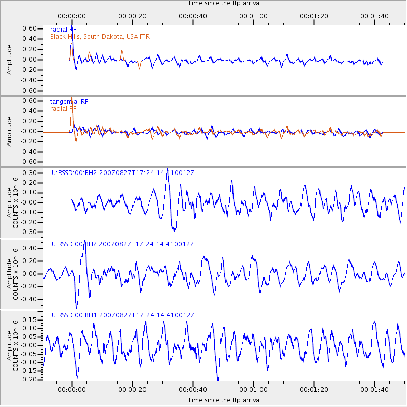
RSSD Black Hills, South Dakota, USA - Earthquake Result Viewer
*The percent match for this event was below the threshold and hence no stack was calculated.
| Earthquake location: |
Tonga Islands Region |
| Earthquake latitude/longitude: |
-17.3/-172.3 |
| Earthquake time(UTC): |
2007/08/27 (239) 17:11:59 GMT |
| Earthquake Depth: |
10 km |
| Earthquake Magnitude: |
5.6 MB, 5.5 MS, 5.7 MW |
| Earthquake Catalog/Contributor: |
WHDF/NEIC |
|
| Network: |
IU Global Seismograph Network (GSN - IRIS/USGS) |
| Station: |
RSSD Black Hills, South Dakota, USA |
| Lat/Lon: |
44.12 N/104.04 W |
| Elevation: |
2060 m |
|
| Distance: |
87.1 deg |
| Az: |
42.039 deg |
| Baz: |
242.649 deg |
| Ray Param: |
$rayparam |
*The percent match for this event was below the threshold and hence was not used in the summary stack. |
|
| Radial Match: |
72.278694 % |
| Radial Bump: |
359 |
| Transverse Match: |
56.828945 % |
| Transverse Bump: |
400 |
| SOD ConfigId: |
590571 |
| Insert Time: |
2013-09-26 14:15:24.652 +0000 |
| GWidth: |
2.5 |
| Max Bumps: |
400 |
| Tol: |
0.001 |
|
Signal To Noise
| Channel | StoN | STA | LTA |
| IU:RSSD:00:BHZ:20070827T17:24:14.410012Z | 7.2268796 | 2.9840822E-7 | 4.1291436E-8 |
| IU:RSSD:00:BH1:20070827T17:24:14.410012Z | 1.816851 | 8.5665754E-8 | 4.7150678E-8 |
| IU:RSSD:00:BH2:20070827T17:24:14.410012Z | 4.21071 | 2.0035152E-7 | 4.7581413E-8 |
| Arrivals |
| Ps | |
| PpPs | |
| PsPs/PpSs | |


