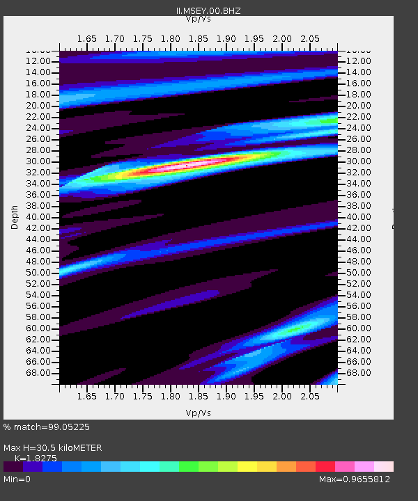
MSEY Mahe, Seychelles - Earthquake Result Viewer
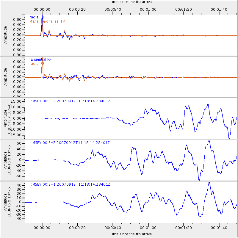
Earthquake location: Southern Sumatra, Indonesia
Earthquake latitude/longitude: -4.4/101.4
Earthquake time(UTC): 2007/09/12 (255) 11:10:26 GMT
Earthquake Depth: 34 km
Earthquake Magnitude: 6.9 MB, 8.5 MS, 8.4 MW, 8.0 ME
Earthquake Catalog/Contributor: WHDF/NEIC
Network: II Global Seismograph Network (GSN - IRIS/IDA)
Station: MSEY Mahe, Seychelles
Lat/Lon: 4.67 S/55.48 E
Elevation: 475 m
Distance: 45.7 deg
Az: 267.81 deg
Baz: 91.636 deg
Ray Param: 0.07101222
Estimated Moho Depth: 30.5 km
Estimated Crust Vp/Vs: 1.83
Assumed Crust Vp: 6.303 km/s
Estimated Crust Vs: 3.449 km/s
Estimated Crust Poisson's Ratio: 0.29
Radial Match: 99.05225 %
Radial Bump: 239
Transverse Match: 89.96625 %
Transverse Bump: 400
SOD ConfigId: 590571
Insert Time: 2013-09-26 14:32:51.891 +0000
GWidth: 2.5
Max Bumps: 400
Tol: 0.001

Signal To Noise

ChannelStoNSTALTA
II:MSEY:00:BHZ:20070912T11:18:14.28401Z4.70471571.3932059E-62.9612968E-7
II:MSEY:00:BH1:20070912T11:18:14.28401Z5.414081.0019917E-61.8507146E-7
II:MSEY:00:BH2:20070912T11:18:14.28401Z2.21471294.857852E-72.1934457E-7
Arrivals
Ps4.2 SECOND
PpPs13 SECOND
PsPs/PpSs17 SECOND