TATO Taipei, Taiwan - Earthquake Result Viewer
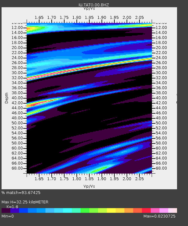
Earthquake location: Southern Sumatra, Indonesia
Earthquake latitude/longitude: -2.6/100.8
Earthquake time(UTC): 2007/09/12 (255) 23:49:03 GMT
Earthquake Depth: 35 km
Earthquake Magnitude: 6.6 MB, 8.1 MS, 7.9 MW, 7.6 ME
Earthquake Catalog/Contributor: WHDF/NEIC
Network: IU Global Seismograph Network (GSN - IRIS/USGS)
Station: TATO Taipei, Taiwan
Lat/Lon: 24.98 N/121.49 E
Elevation: 53 m
Distance: 34.0 deg
Az: 34.937 deg
Baz: 219.076 deg
Ray Param: 0.07790296
Estimated Moho Depth: 32.25 km
Estimated Crust Vp/Vs: 1.60
Assumed Crust Vp: 6.289 km/s
Estimated Crust Vs: 3.93 km/s
Estimated Crust Poisson's Ratio: 0.18
Radial Match: 93.67425 %
Radial Bump: 285
Transverse Match: 82.0262 %
Transverse Bump: 400
SOD ConfigId: 590571
Insert Time: 2013-09-26 14:37:38.537 +0000
GWidth: 2.5
Max Bumps: 400
Tol: 0.001

Signal To Noise

ChannelStoNSTALTA
IU:TATO:00:BHZ:20070912T23:55:13.648009Z49.9595456.724236E-51.3459362E-6
IU:TATO:00:BH1:20070912T23:55:13.648009Z9.8319981.30643175E-51.328755E-6
IU:TATO:00:BH2:20070912T23:55:13.648009Z21.920543.115162E-51.4211155E-6
Arrivals
Ps3.3 SECOND
PpPs12 SECOND
PsPs/PpSs16 SECOND