TATO Taipei, Taiwan - Earthquake Result Viewer
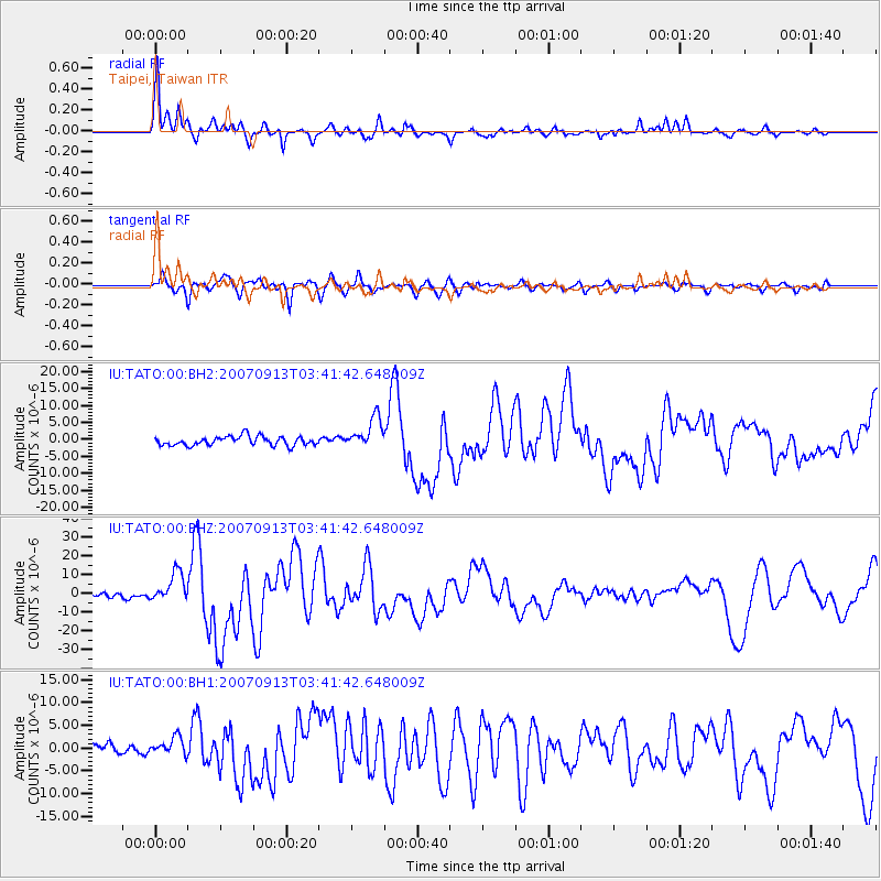
Earthquake location: Southern Sumatra, Indonesia
Earthquake latitude/longitude: -2.1/99.6
Earthquake time(UTC): 2007/09/13 (256) 03:35:28 GMT
Earthquake Depth: 22 km
Earthquake Magnitude: 6.3 MB, 7.2 MS, 7.0 MW, 7.1 ME
Earthquake Catalog/Contributor: WHDF/NEIC
Network: IU Global Seismograph Network (GSN - IRIS/USGS)
Station: TATO Taipei, Taiwan
Lat/Lon: 24.98 N/121.49 E
Elevation: 53 m
Distance: 34.3 deg
Az: 36.862 deg
Baz: 221.341 deg
Ray Param: 0.077790774
Estimated Moho Depth: 10.5 km
Estimated Crust Vp/Vs: 1.98
Assumed Crust Vp: 6.289 km/s
Estimated Crust Vs: 3.172 km/s
Estimated Crust Poisson's Ratio: 0.33
Radial Match: 92.04978 %
Radial Bump: 336
Transverse Match: 86.92749 %
Transverse Bump: 400
SOD ConfigId: 590571
Insert Time: 2013-09-26 14:39:59.805 +0000
GWidth: 2.5
Max Bumps: 400
Tol: 0.001

Signal To Noise

ChannelStoNSTALTA
IU:TATO:00:BHZ:20070913T03:41:42.648009Z5.48703057.87325E-61.4348836E-6
IU:TATO:00:BH1:20070913T03:41:42.648009Z1.4809831.9198662E-61.2963459E-6
IU:TATO:00:BH2:20070913T03:41:42.648009Z3.42738824.594625E-61.3405615E-6
Arrivals
Ps1.8 SECOND
PpPs4.7 SECOND
PsPs/PpSs6.4 SECOND