You are here: Home > Network List > IU - Global Seismograph Network (GSN - IRIS/USGS) Stations List
> Station RSSD Black Hills, South Dakota, USA > Earthquake Result Viewer
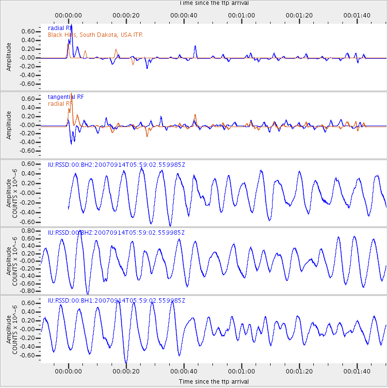
RSSD Black Hills, South Dakota, USA - Earthquake Result Viewer
*The percent match for this event was below the threshold and hence no stack was calculated.
| Earthquake location: |
Fiji Islands Region |
| Earthquake latitude/longitude: |
-15.5/-176.2 |
| Earthquake time(UTC): |
2007/09/14 (257) 05:46:45 GMT |
| Earthquake Depth: |
35 km |
| Earthquake Magnitude: |
5.7 MW, 5.6 MS |
| Earthquake Catalog/Contributor: |
NEIC PDE/NEIC PDE-M |
|
| Network: |
IU Global Seismograph Network (GSN - IRIS/USGS) |
| Station: |
RSSD Black Hills, South Dakota, USA |
| Lat/Lon: |
44.12 N/104.04 W |
| Elevation: |
2060 m |
|
| Distance: |
88.3 deg |
| Az: |
43.3 deg |
| Baz: |
246.667 deg |
| Ray Param: |
$rayparam |
*The percent match for this event was below the threshold and hence was not used in the summary stack. |
|
| Radial Match: |
70.23371 % |
| Radial Bump: |
241 |
| Transverse Match: |
61.409508 % |
| Transverse Bump: |
400 |
| SOD ConfigId: |
590571 |
| Insert Time: |
2013-09-26 14:48:32.932 +0000 |
| GWidth: |
2.5 |
| Max Bumps: |
400 |
| Tol: |
0.001 |
|
Signal To Noise
| Channel | StoN | STA | LTA |
| IU:RSSD:00:BHZ:20070914T05:59:02.559985Z | 2.045805 | 5.4527595E-7 | 2.6653368E-7 |
| IU:RSSD:00:BH1:20070914T05:59:02.559985Z | 1.4791716 | 3.4589806E-7 | 2.338458E-7 |
| IU:RSSD:00:BH2:20070914T05:59:02.559985Z | 1.2970418 | 3.6136572E-7 | 2.7860762E-7 |
| Arrivals |
| Ps | |
| PpPs | |
| PsPs/PpSs | |


