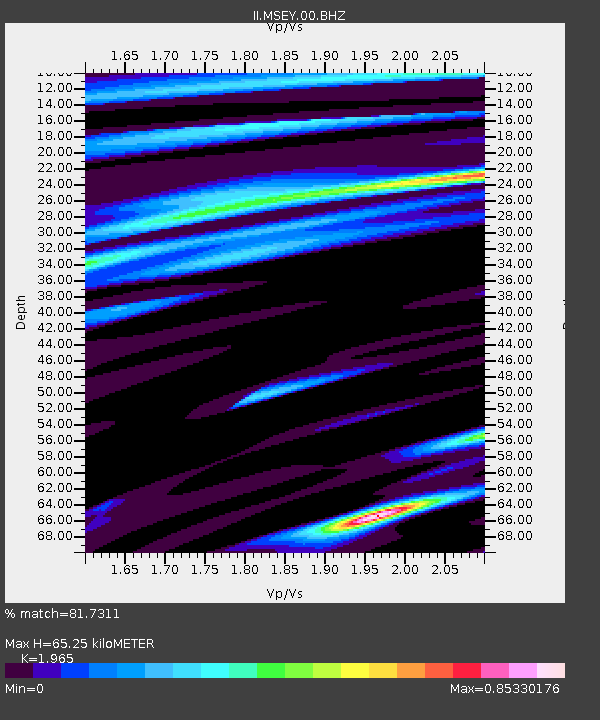
MSEY Mahe, Seychelles - Earthquake Result Viewer

Earthquake location: Southern Sumatra, Indonesia
Earthquake latitude/longitude: -4.1/101.2
Earthquake time(UTC): 2007/09/14 (257) 06:01:32 GMT
Earthquake Depth: 23 km
Earthquake Magnitude: 5.9 MB, 6.3 MS, 6.2 MW, 6.0 ME
Earthquake Catalog/Contributor: WHDF/NEIC
Network: II Global Seismograph Network (GSN - IRIS/IDA)
Station: MSEY Mahe, Seychelles
Lat/Lon: 4.67 S/55.48 E
Elevation: 475 m
Distance: 45.6 deg
Az: 267.464 deg
Baz: 91.12 deg
Ray Param: 0.07116466
Estimated Moho Depth: 65.25 km
Estimated Crust Vp/Vs: 1.97
Assumed Crust Vp: 6.303 km/s
Estimated Crust Vs: 3.207 km/s
Estimated Crust Poisson's Ratio: 0.33
Radial Match: 81.7311 %
Radial Bump: 346
Transverse Match: 72.98025 %
Transverse Bump: 400
SOD ConfigId: 590571
Insert Time: 2013-09-26 14:49:13.832 +0000
GWidth: 2.5
Max Bumps: 400
Tol: 0.001

Signal To Noise

ChannelStoNSTALTA
II:MSEY:00:BHZ:20070914T06:09:19.451Z2.31204847.7019695E-73.3312315E-7
II:MSEY:00:BH1:20070914T06:09:19.451Z1.09731252.948813E-72.6873045E-7
II:MSEY:00:BH2:20070914T06:09:19.451Z1.51665212.733099E-71.8020604E-7
Arrivals
Ps11 SECOND
PpPs29 SECOND
PsPs/PpSs40 SECOND