You are here: Home > Network List > IU - Global Seismograph Network (GSN - IRIS/USGS) Stations List
> Station RSSD Black Hills, South Dakota, USA > Earthquake Result Viewer
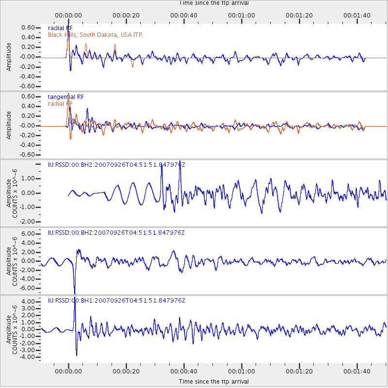
RSSD Black Hills, South Dakota, USA - Earthquake Result Viewer
*The percent match for this event was below the threshold and hence no stack was calculated.
| Earthquake location: |
Near Coast Of Ecuador |
| Earthquake latitude/longitude: |
-3.9/-79.2 |
| Earthquake time(UTC): |
2007/09/26 (269) 04:43:17 GMT |
| Earthquake Depth: |
100 km |
| Earthquake Magnitude: |
6.1 MB, 5.9 MW, 5.9 MW |
| Earthquake Catalog/Contributor: |
WHDF/NEIC |
|
| Network: |
IU Global Seismograph Network (GSN - IRIS/USGS) |
| Station: |
RSSD Black Hills, South Dakota, USA |
| Lat/Lon: |
44.12 N/104.04 W |
| Elevation: |
2060 m |
|
| Distance: |
52.8 deg |
| Az: |
337.677 deg |
| Baz: |
148.253 deg |
| Ray Param: |
$rayparam |
*The percent match for this event was below the threshold and hence was not used in the summary stack. |
|
| Radial Match: |
78.71401 % |
| Radial Bump: |
400 |
| Transverse Match: |
80.37437 % |
| Transverse Bump: |
400 |
| SOD ConfigId: |
590571 |
| Insert Time: |
2013-09-26 15:06:03.268 +0000 |
| GWidth: |
2.5 |
| Max Bumps: |
400 |
| Tol: |
0.001 |
|
Signal To Noise
| Channel | StoN | STA | LTA |
| IU:RSSD:00:BHZ:20070926T04:51:51.847976Z | 4.4220347 | 2.3005045E-6 | 5.2023665E-7 |
| IU:RSSD:00:BH1:20070926T04:51:51.847976Z | 3.760094 | 1.5732016E-6 | 4.1839422E-7 |
| IU:RSSD:00:BH2:20070926T04:51:51.847976Z | 2.1452672 | 6.9741964E-7 | 3.2509686E-7 |
| Arrivals |
| Ps | |
| PpPs | |
| PsPs/PpSs | |


