You are here: Home > Network List > IU - Global Seismograph Network (GSN - IRIS/USGS) Stations List
> Station RSSD Black Hills, South Dakota, USA > Earthquake Result Viewer
RSSD Black Hills, South Dakota, USA - Earthquake Result Viewer
| Earthquake location: |
Volcano Islands, Japan Region |
| Earthquake latitude/longitude: |
22.0/142.7 |
| Earthquake time(UTC): |
2007/09/28 (271) 13:38:59 GMT |
| Earthquake Depth: |
276 km |
| Earthquake Magnitude: |
6.7 MB, 7.4 MW, 7.4 MW |
| Earthquake Catalog/Contributor: |
WHDF/NEIC |
|
| Network: |
IU Global Seismograph Network (GSN - IRIS/USGS) |
| Station: |
RSSD Black Hills, South Dakota, USA |
| Lat/Lon: |
44.12 N/104.04 W |
| Elevation: |
2060 m |
|
| Distance: |
90.3 deg |
| Az: |
41.409 deg |
| Baz: |
301.54 deg |
| Ray Param: |
0.04161622 |
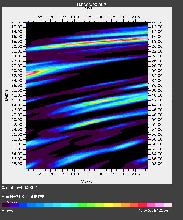
| Estimated Moho Depth: |
31.0 km |
| Estimated Crust Vp/Vs: |
1.60 |
| Assumed Crust Vp: |
6.242 km/s |
| Estimated Crust Vs: |
3.901 km/s |
| Estimated Crust Poisson's Ratio: |
0.18 |
|
| Radial Match: |
96.58921 % |
| Radial Bump: |
396 |
| Transverse Match: |
90.84385 % |
| Transverse Bump: |
400 |
| SOD ConfigId: |
590571 |
| Insert Time: |
2013-09-26 15:19:23.622 +0000 |
| GWidth: |
2.5 |
| Max Bumps: |
400 |
| Tol: |
0.001 |
|
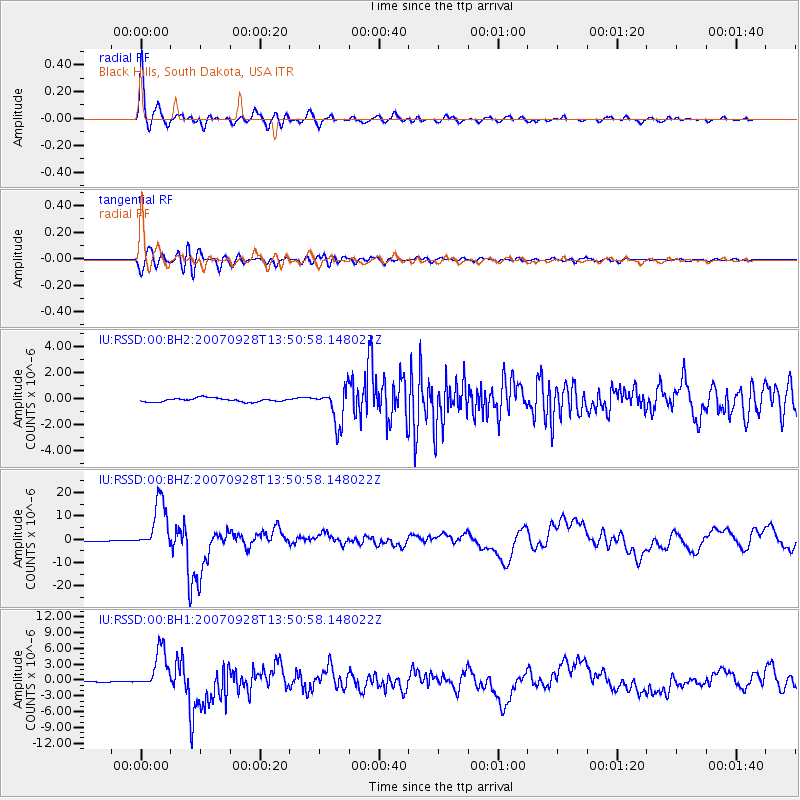
Signal To Noise
| Channel | StoN | STA | LTA |
| IU:RSSD:00:BHZ:20070928T13:50:58.148022Z | 45.846745 | 1.0640798E-5 | 2.3209495E-7 |
| IU:RSSD:00:BH1:20070928T13:50:58.148022Z | 45.398758 | 3.8214857E-6 | 8.4176E-8 |
| IU:RSSD:00:BH2:20070928T13:50:58.148022Z | 9.487147 | 1.3522227E-6 | 1.4253207E-7 |
| Arrivals |
| Ps | 3.0 SECOND |
| PpPs | 13 SECOND |
| PsPs/PpSs | 16 SECOND |


