You are here: Home > Network List > TA - USArray Transportable Network (new EarthScope stations) Stations List
> Station O48A Farmland, IN, USA > Earthquake Result Viewer
O48A Farmland, IN, USA - Earthquake Result Viewer
*The percent match for this event was below the threshold and hence no stack was calculated.
| Earthquake location: |
Southern East Pacific Rise |
| Earthquake latitude/longitude: |
-32.1/-110.8 |
| Earthquake time(UTC): |
2014/10/10 (283) 18:59:00 GMT |
| Earthquake Depth: |
10 km |
| Earthquake Magnitude: |
5.4 MW |
| Earthquake Catalog/Contributor: |
ISC/ISC |
|
| Network: |
TA USArray Transportable Network (new EarthScope stations) |
| Station: |
O48A Farmland, IN, USA |
| Lat/Lon: |
40.26 N/85.16 W |
| Elevation: |
300 m |
|
| Distance: |
75.8 deg |
| Az: |
19.973 deg |
| Baz: |
202.258 deg |
| Ray Param: |
$rayparam |
*The percent match for this event was below the threshold and hence was not used in the summary stack. |
|
| Radial Match: |
74.665436 % |
| Radial Bump: |
400 |
| Transverse Match: |
57.63794 % |
| Transverse Bump: |
400 |
| SOD ConfigId: |
3390531 |
| Insert Time: |
2019-04-14 11:33:03.141 +0000 |
| GWidth: |
2.5 |
| Max Bumps: |
400 |
| Tol: |
0.001 |
|
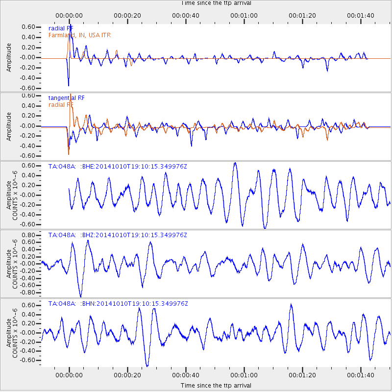
Signal To Noise
| Channel | StoN | STA | LTA |
| TA:O48A: :BHZ:20141010T19:10:15.349976Z | 2.7613978 | 4.7624695E-7 | 1.724659E-7 |
| TA:O48A: :BHN:20141010T19:10:15.349976Z | 1.317335 | 1.8266027E-7 | 1.3865893E-7 |
| TA:O48A: :BHE:20141010T19:10:15.349976Z | 1.5174092 | 2.6862742E-7 | 1.7703032E-7 |
| Arrivals |
| Ps | |
| PpPs | |
| PsPs/PpSs | |


