You are here: Home > Network List > TA - USArray Transportable Network (new EarthScope stations) Stations List
> Station T57A Hurt, VA, USA > Earthquake Result Viewer
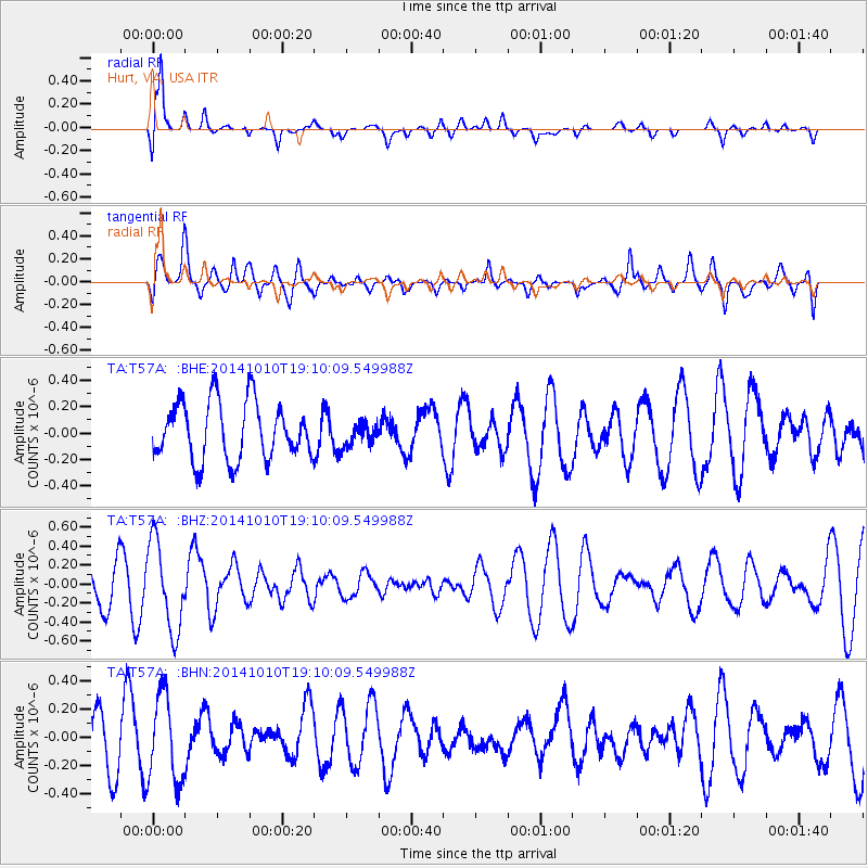
T57A Hurt, VA, USA - Earthquake Result Viewer
*The percent match for this event was below the threshold and hence no stack was calculated.
| Earthquake location: |
Southern East Pacific Rise |
| Earthquake latitude/longitude: |
-32.1/-110.8 |
| Earthquake time(UTC): |
2014/10/10 (283) 18:59:00 GMT |
| Earthquake Depth: |
10 km |
| Earthquake Magnitude: |
5.4 MW |
| Earthquake Catalog/Contributor: |
ISC/ISC |
|
| Network: |
TA USArray Transportable Network (new EarthScope stations) |
| Station: |
T57A Hurt, VA, USA |
| Lat/Lon: |
37.00 N/79.25 W |
| Elevation: |
230 m |
|
| Distance: |
74.8 deg |
| Az: |
25.72 deg |
| Baz: |
207.389 deg |
| Ray Param: |
$rayparam |
*The percent match for this event was below the threshold and hence was not used in the summary stack. |
|
| Radial Match: |
87.07522 % |
| Radial Bump: |
400 |
| Transverse Match: |
46.82464 % |
| Transverse Bump: |
400 |
| SOD ConfigId: |
3390531 |
| Insert Time: |
2019-04-14 11:33:16.059 +0000 |
| GWidth: |
2.5 |
| Max Bumps: |
400 |
| Tol: |
0.001 |
|
Signal To Noise
| Channel | StoN | STA | LTA |
| TA:T57A: :BHZ:20141010T19:10:09.549988Z | 2.0567026 | 4.663728E-7 | 2.2675752E-7 |
| TA:T57A: :BHN:20141010T19:10:09.549988Z | 2.1219764 | 3.082453E-7 | 1.452633E-7 |
| TA:T57A: :BHE:20141010T19:10:09.549988Z | 0.40826553 | 8.882504E-8 | 2.1756684E-7 |
| Arrivals |
| Ps | |
| PpPs | |
| PsPs/PpSs | |


