You are here: Home > Network List > IU - Global Seismograph Network (GSN - IRIS/USGS) Stations List
> Station RSSD Black Hills, South Dakota, USA > Earthquake Result Viewer
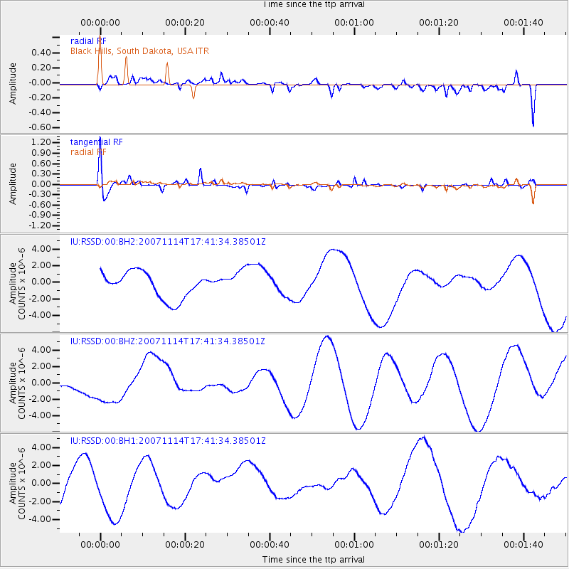
RSSD Black Hills, South Dakota, USA - Earthquake Result Viewer
*The percent match for this event was below the threshold and hence no stack was calculated.
| Earthquake location: |
Near Coast Of Guatemala |
| Earthquake latitude/longitude: |
13.8/-90.7 |
| Earthquake time(UTC): |
2007/11/14 (318) 17:35:41 GMT |
| Earthquake Depth: |
57 km |
| Earthquake Magnitude: |
5.6 MD |
| Earthquake Catalog/Contributor: |
NEIC PDE/NEIC PDE-M |
|
| Network: |
IU Global Seismograph Network (GSN - IRIS/USGS) |
| Station: |
RSSD Black Hills, South Dakota, USA |
| Lat/Lon: |
44.12 N/104.04 W |
| Elevation: |
2060 m |
|
| Distance: |
32.3 deg |
| Az: |
341.946 deg |
| Baz: |
155.289 deg |
| Ray Param: |
$rayparam |
*The percent match for this event was below the threshold and hence was not used in the summary stack. |
|
| Radial Match: |
44.587673 % |
| Radial Bump: |
400 |
| Transverse Match: |
70.92761 % |
| Transverse Bump: |
400 |
| SOD ConfigId: |
590571 |
| Insert Time: |
2013-09-26 16:31:11.005 +0000 |
| GWidth: |
2.5 |
| Max Bumps: |
400 |
| Tol: |
0.001 |
|
Signal To Noise
| Channel | StoN | STA | LTA |
| IU:RSSD:00:BHZ:20071114T17:41:34.38501Z | 1.4252267 | 2.4081064E-6 | 1.6896305E-6 |
| IU:RSSD:00:BH1:20071114T17:41:34.38501Z | 2.0433156 | 3.2613475E-6 | 1.5961054E-6 |
| IU:RSSD:00:BH2:20071114T17:41:34.38501Z | 1.0043691 | 1.573947E-6 | 1.5671001E-6 |
| Arrivals |
| Ps | |
| PpPs | |
| PsPs/PpSs | |


