You are here: Home > Network List > IU - Global Seismograph Network (GSN - IRIS/USGS) Stations List
> Station RCBR Riachuelo, Brazil > Earthquake Result Viewer
RCBR Riachuelo, Brazil - Earthquake Result Viewer
| Earthquake location: |
Peru-Ecuador Border Region |
| Earthquake latitude/longitude: |
-2.3/-77.8 |
| Earthquake time(UTC): |
2007/11/16 (320) 03:13:00 GMT |
| Earthquake Depth: |
123 km |
| Earthquake Magnitude: |
6.3 MB, 6.8 MW, 6.7 MW |
| Earthquake Catalog/Contributor: |
WHDF/NEIC |
|
| Network: |
IU Global Seismograph Network (GSN - IRIS/USGS) |
| Station: |
RCBR Riachuelo, Brazil |
| Lat/Lon: |
5.83 S/35.90 W |
| Elevation: |
409 m |
|
| Distance: |
42.0 deg |
| Az: |
96.106 deg |
| Baz: |
273.009 deg |
| Ray Param: |
0.0730363 |
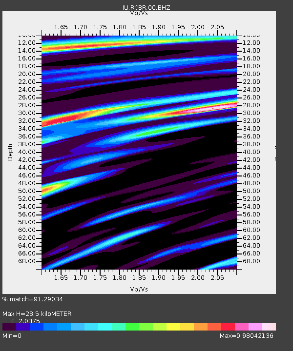
| Estimated Moho Depth: |
28.5 km |
| Estimated Crust Vp/Vs: |
2.04 |
| Assumed Crust Vp: |
6.391 km/s |
| Estimated Crust Vs: |
3.137 km/s |
| Estimated Crust Poisson's Ratio: |
0.34 |
|
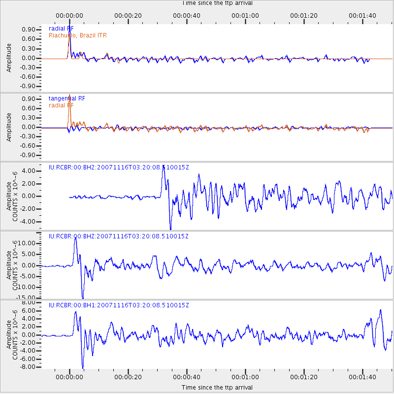
| Radial Match: |
91.29034 % |
| Radial Bump: |
400 |
| Transverse Match: |
70.71173 % |
| Transverse Bump: |
400 |
| SOD ConfigId: |
590571 |
| Insert Time: |
2013-09-26 16:38:57.534 +0000 |
| GWidth: |
2.5 |
| Max Bumps: |
400 |
| Tol: |
0.001 |
|
Signal To Noise
| Channel | StoN | STA | LTA |
| IU:RCBR:00:BHZ:20071116T03:20:08.510015Z | 40.540173 | 7.14593E-6 | 1.7626787E-7 |
| IU:RCBR:00:BH1:20071116T03:20:08.510015Z | 30.564388 | 3.6955041E-6 | 1.2090882E-7 |
| IU:RCBR:00:BH2:20071116T03:20:08.510015Z | 17.131674 | 2.6159487E-6 | 1.5269661E-7 |
| Arrivals |
| Ps | 4.9 SECOND |
| PpPs | 13 SECOND |
| PsPs/PpSs | 18 SECOND |


