You are here: Home > Network List > IU - Global Seismograph Network (GSN - IRIS/USGS) Stations List
> Station RSSD Black Hills, South Dakota, USA > Earthquake Result Viewer
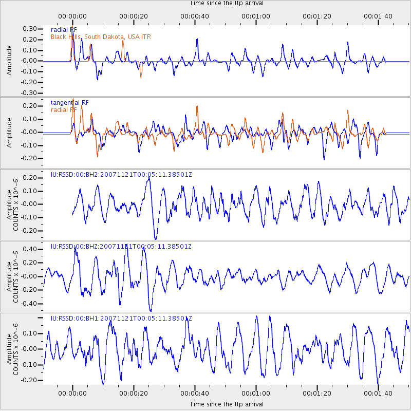
RSSD Black Hills, South Dakota, USA - Earthquake Result Viewer
*The percent match for this event was below the threshold and hence no stack was calculated.
| Earthquake location: |
Tonga Islands |
| Earthquake latitude/longitude: |
-17.8/-173.2 |
| Earthquake time(UTC): |
2007/11/20 (324) 23:52:55 GMT |
| Earthquake Depth: |
35 km |
| Earthquake Magnitude: |
5.7 MW, 5.5 MS, 5.6 MB |
| Earthquake Catalog/Contributor: |
NEIC PDE/NEIC PDE-M |
|
| Network: |
IU Global Seismograph Network (GSN - IRIS/USGS) |
| Station: |
RSSD Black Hills, South Dakota, USA |
| Lat/Lon: |
44.12 N/104.04 W |
| Elevation: |
2060 m |
|
| Distance: |
88.1 deg |
| Az: |
42.344 deg |
| Baz: |
242.989 deg |
| Ray Param: |
$rayparam |
*The percent match for this event was below the threshold and hence was not used in the summary stack. |
|
| Radial Match: |
53.052265 % |
| Radial Bump: |
400 |
| Transverse Match: |
59.67929 % |
| Transverse Bump: |
400 |
| SOD ConfigId: |
590571 |
| Insert Time: |
2013-09-26 16:53:26.464 +0000 |
| GWidth: |
2.5 |
| Max Bumps: |
400 |
| Tol: |
0.001 |
|
Signal To Noise
| Channel | StoN | STA | LTA |
| IU:RSSD:00:BHZ:20071121T00:05:11.38501Z | 1.6060752 | 2.2875541E-7 | 1.4243132E-7 |
| IU:RSSD:00:BH1:20071121T00:05:11.38501Z | 0.57371736 | 5.8156E-8 | 1.01366986E-7 |
| IU:RSSD:00:BH2:20071121T00:05:11.38501Z | 1.0891919 | 7.744531E-8 | 7.110346E-8 |
| Arrivals |
| Ps | |
| PpPs | |
| PsPs/PpSs | |


