You are here: Home > Network List > ER - Mount Erebus Volcano Observatory Seismic Network Stations List
> Station E1S PLACE HOLDER, Mt. Erebus Volcano Seismic Network > Earthquake Result Viewer
E1S PLACE HOLDER, Mt. Erebus Volcano Seismic Network - Earthquake Result Viewer
| Earthquake location: |
Eastern New Guinea Reg., P.N.G. |
| Earthquake latitude/longitude: |
-5.8/147.1 |
| Earthquake time(UTC): |
2007/11/22 (326) 08:48:27 GMT |
| Earthquake Depth: |
53 km |
| Earthquake Magnitude: |
6.0 MB, 6.7 MW, 6.7 MW |
| Earthquake Catalog/Contributor: |
WHDF/NEIC |
|
| Network: |
ER Mount Erebus Volcano Observatory Seismic Network |
| Station: |
E1S PLACE HOLDER, Mt. Erebus Volcano Seismic Network |
| Lat/Lon: |
77.53 S/167.14 E |
| Elevation: |
3712 m |
|
| Distance: |
72.5 deg |
| Az: |
175.522 deg |
| Baz: |
339.053 deg |
| Ray Param: |
0.053503398 |
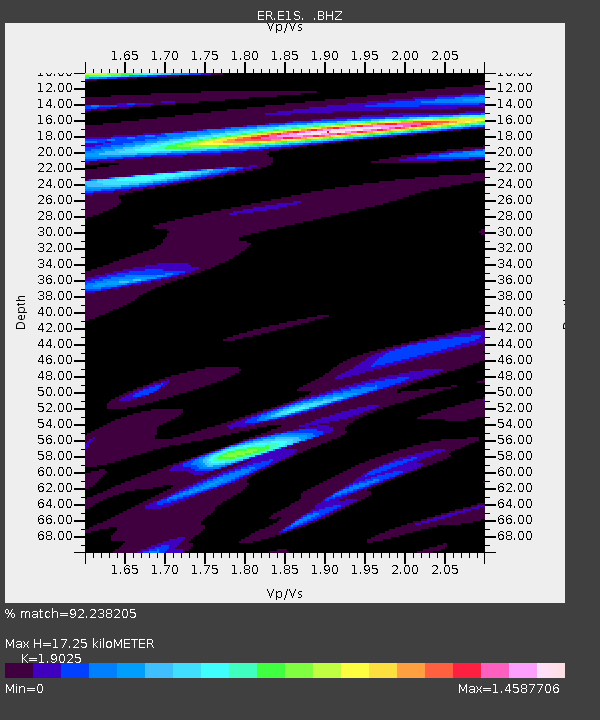
| Estimated Moho Depth: |
17.25 km |
| Estimated Crust Vp/Vs: |
1.90 |
| Assumed Crust Vp: |
6.183 km/s |
| Estimated Crust Vs: |
3.25 km/s |
| Estimated Crust Poisson's Ratio: |
0.31 |
|
| Radial Match: |
92.238205 % |
| Radial Bump: |
400 |
| Transverse Match: |
81.95805 % |
| Transverse Bump: |
400 |
| SOD ConfigId: |
590571 |
| Insert Time: |
2013-09-26 16:55:23.504 +0000 |
| GWidth: |
2.5 |
| Max Bumps: |
400 |
| Tol: |
0.001 |
|

Signal To Noise
| Channel | StoN | STA | LTA |
| ER:E1S: :BHZ:20071122T08:59:17.874971Z | 9.397028 | 1.6461709E-6 | 1.7517993E-7 |
| ER:E1S: :BH1:20071122T08:59:17.874971Z | 1.3484653 | 3.5390073E-7 | 2.6244703E-7 |
| ER:E1S: :BH2:20071122T08:59:17.874971Z | 1.8416069 | 9.4125335E-7 | 5.111044E-7 |
| Arrivals |
| Ps | 2.6 SECOND |
| PpPs | 7.9 SECOND |
| PsPs/PpSs | 10 SECOND |


