You are here: Home > Network List > IU - Global Seismograph Network (GSN - IRIS/USGS) Stations List
> Station RSSD Black Hills, South Dakota, USA > Earthquake Result Viewer
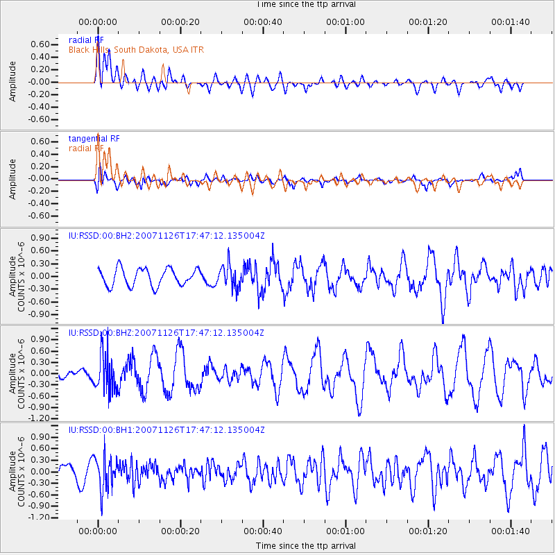
RSSD Black Hills, South Dakota, USA - Earthquake Result Viewer
*The percent match for this event was below the threshold and hence no stack was calculated.
| Earthquake location: |
Near Coast Of Chiapas, Mexico |
| Earthquake latitude/longitude: |
15.3/-93.4 |
| Earthquake time(UTC): |
2007/11/26 (330) 17:41:40 GMT |
| Earthquake Depth: |
87 km |
| Earthquake Magnitude: |
5.7 MW, 5.6 MW |
| Earthquake Catalog/Contributor: |
NEIC PDE/NEIC PDE-M |
|
| Network: |
IU Global Seismograph Network (GSN - IRIS/USGS) |
| Station: |
RSSD Black Hills, South Dakota, USA |
| Lat/Lon: |
44.12 N/104.04 W |
| Elevation: |
2060 m |
|
| Distance: |
30.1 deg |
| Az: |
344.598 deg |
| Baz: |
159.151 deg |
| Ray Param: |
$rayparam |
*The percent match for this event was below the threshold and hence was not used in the summary stack. |
|
| Radial Match: |
61.052208 % |
| Radial Bump: |
400 |
| Transverse Match: |
76.63598 % |
| Transverse Bump: |
400 |
| SOD ConfigId: |
590571 |
| Insert Time: |
2013-09-26 17:10:56.418 +0000 |
| GWidth: |
2.5 |
| Max Bumps: |
400 |
| Tol: |
0.001 |
|
Signal To Noise
| Channel | StoN | STA | LTA |
| IU:RSSD:00:BHZ:20071126T17:47:12.135004Z | 2.7317789 | 5.047927E-7 | 1.8478534E-7 |
| IU:RSSD:00:BH1:20071126T17:47:12.135004Z | 2.3685822 | 4.3117035E-7 | 1.8203731E-7 |
| IU:RSSD:00:BH2:20071126T17:47:12.135004Z | 1.3053253 | 2.649549E-7 | 2.0297998E-7 |
| Arrivals |
| Ps | |
| PpPs | |
| PsPs/PpSs | |


