You are here: Home > Network List > CI - Caltech Regional Seismic Network Stations List
> Station TIN Tinemaha, California, USA > Earthquake Result Viewer
TIN Tinemaha, California, USA - Earthquake Result Viewer
| Earthquake location: |
Fiji Islands Region |
| Earthquake latitude/longitude: |
-21.7/-176.7 |
| Earthquake time(UTC): |
2001/07/04 (185) 07:06:31 GMT |
| Earthquake Depth: |
185 km |
| Earthquake Magnitude: |
5.9 MB, 5.8 MS, 6.5 MW, 6.5 MW |
| Earthquake Catalog/Contributor: |
WHDF/NEIC |
|
| Network: |
CI Caltech Regional Seismic Network |
| Station: |
TIN Tinemaha, California, USA |
| Lat/Lon: |
37.05 N/118.23 W |
| Elevation: |
1164 m |
|
| Distance: |
80.3 deg |
| Az: |
43.771 deg |
| Baz: |
233.517 deg |
| Ray Param: |
0.047909662 |
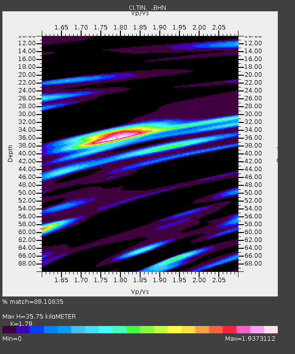
| Estimated Moho Depth: |
35.75 km |
| Estimated Crust Vp/Vs: |
1.79 |
| Assumed Crust Vp: |
6.291 km/s |
| Estimated Crust Vs: |
3.515 km/s |
| Estimated Crust Poisson's Ratio: |
0.27 |
|
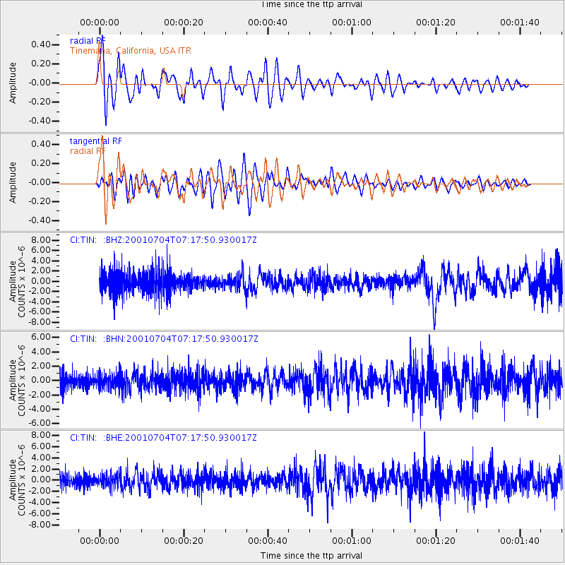
| Radial Match: |
89.10835 % |
| Radial Bump: |
400 |
| Transverse Match: |
83.8279 % |
| Transverse Bump: |
400 |
| SOD ConfigId: |
3770 |
| Insert Time: |
2010-02-25 20:46:02.345 +0000 |
| GWidth: |
2.5 |
| Max Bumps: |
400 |
| Tol: |
0.001 |
|
Signal To Noise
| Channel | StoN | STA | LTA |
| CI:TIN: :BHN:20010704T07:17:50.930017Z | 0.64298123 | 1.023725E-6 | 1.5921537E-6 |
| CI:TIN: :BHE:20010704T07:17:50.930017Z | 0.5685913 | 1.0435932E-6 | 1.8354013E-6 |
| CI:TIN: :BHZ:20010704T07:17:50.930017Z | 0.67821777 | 1.4077796E-6 | 2.0757043E-6 |
| Arrivals |
| Ps | 4.6 SECOND |
| PpPs | 15 SECOND |
| PsPs/PpSs | 20 SECOND |


