You are here: Home > Network List > II - Global Seismograph Network (GSN - IRIS/IDA) Stations List
> Station MBAR Mbarara, Uganda > Earthquake Result Viewer
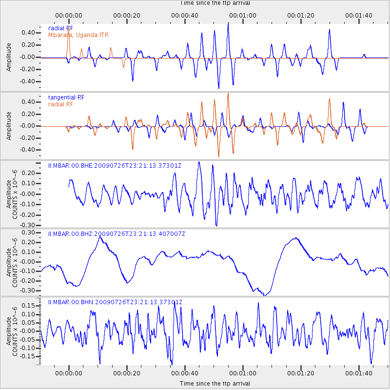
MBAR Mbarara, Uganda - Earthquake Result Viewer
*The percent match for this event was below the threshold and hence no stack was calculated.
| Earthquake location: |
Southern Sumatra, Indonesia |
| Earthquake latitude/longitude: |
-4.8/102.9 |
| Earthquake time(UTC): |
2009/07/26 (207) 23:10:24 GMT |
| Earthquake Depth: |
47 km |
| Earthquake Magnitude: |
6.0 MB, 5.7 MW, 5.6 MW |
| Earthquake Catalog/Contributor: |
WHDF/NEIC |
|
| Network: |
II Global Seismograph Network (GSN - IRIS/IDA) |
| Station: |
MBAR Mbarara, Uganda |
| Lat/Lon: |
0.60 S/30.74 E |
| Elevation: |
1390 m |
|
| Distance: |
72.2 deg |
| Az: |
270.905 deg |
| Baz: |
94.813 deg |
| Ray Param: |
$rayparam |
*The percent match for this event was below the threshold and hence was not used in the summary stack. |
|
| Radial Match: |
38.171177 % |
| Radial Bump: |
400 |
| Transverse Match: |
37.779274 % |
| Transverse Bump: |
400 |
| SOD ConfigId: |
2648 |
| Insert Time: |
2010-03-01 15:11:49.327 +0000 |
| GWidth: |
2.5 |
| Max Bumps: |
400 |
| Tol: |
0.001 |
|
Signal To Noise
| Channel | StoN | STA | LTA |
| II:MBAR:00:BHZ:20090726T23:21:13.407007Z | 1.8076433 | 2.6333728E-7 | 1.4567989E-7 |
| II:MBAR:00:BHN:20090726T23:21:13.37301Z | 1.0939412 | 4.322962E-8 | 3.9517314E-8 |
| II:MBAR:00:BHE:20090726T23:21:13.37301Z | 0.7936565 | 5.319802E-8 | 6.702902E-8 |
| Arrivals |
| Ps | |
| PpPs | |
| PsPs/PpSs | |


