You are here: Home > Network List > IU - Global Seismograph Network (GSN - IRIS/USGS) Stations List
> Station RSSD Black Hills, South Dakota, USA > Earthquake Result Viewer
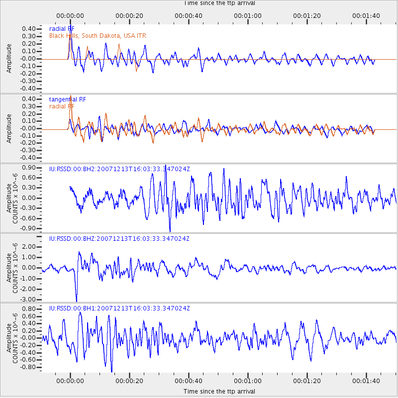
RSSD Black Hills, South Dakota, USA - Earthquake Result Viewer
*The percent match for this event was below the threshold and hence no stack was calculated.
| Earthquake location: |
Samoa Islands Region |
| Earthquake latitude/longitude: |
-15.2/-172.4 |
| Earthquake time(UTC): |
2007/12/13 (347) 15:51:27 GMT |
| Earthquake Depth: |
17 km |
| Earthquake Magnitude: |
6.2 MW, 6.0 MW, 6.0 MS, 6.0 MB |
| Earthquake Catalog/Contributor: |
NEIC PDE/NEIC PDE-M |
|
| Network: |
IU Global Seismograph Network (GSN - IRIS/USGS) |
| Station: |
RSSD Black Hills, South Dakota, USA |
| Lat/Lon: |
44.12 N/104.04 W |
| Elevation: |
2060 m |
|
| Distance: |
85.7 deg |
| Az: |
42.163 deg |
| Baz: |
244.127 deg |
| Ray Param: |
$rayparam |
*The percent match for this event was below the threshold and hence was not used in the summary stack. |
|
| Radial Match: |
76.44927 % |
| Radial Bump: |
400 |
| Transverse Match: |
62.28024 % |
| Transverse Bump: |
400 |
| SOD ConfigId: |
590571 |
| Insert Time: |
2013-09-26 17:41:26.794 +0000 |
| GWidth: |
2.5 |
| Max Bumps: |
400 |
| Tol: |
0.001 |
|
Signal To Noise
| Channel | StoN | STA | LTA |
| IU:RSSD:00:BHZ:20071213T16:03:33.347024Z | 4.6855335 | 1.0865521E-6 | 2.3189506E-7 |
| IU:RSSD:00:BH1:20071213T16:03:33.347024Z | 3.4670143 | 4.1608575E-7 | 1.200127E-7 |
| IU:RSSD:00:BH2:20071213T16:03:33.347024Z | 2.507341 | 4.3634972E-7 | 1.7402888E-7 |
| Arrivals |
| Ps | |
| PpPs | |
| PsPs/PpSs | |


