You are here: Home > Network List > IU - Global Seismograph Network (GSN - IRIS/USGS) Stations List
> Station RSSD Black Hills, South Dakota, USA > Earthquake Result Viewer
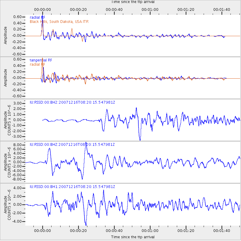
RSSD Black Hills, South Dakota, USA - Earthquake Result Viewer
*The percent match for this event was below the threshold and hence no stack was calculated.
| Earthquake location: |
Near Coast Of Northern Chile |
| Earthquake latitude/longitude: |
-23.0/-70.2 |
| Earthquake time(UTC): |
2007/12/16 (350) 08:09:17 GMT |
| Earthquake Depth: |
45 km |
| Earthquake Magnitude: |
6.7 MW, 6.2 MB, 6.4 MS, 6.7 MW |
| Earthquake Catalog/Contributor: |
NEIC PDE/NEIC PDE-M |
|
| Network: |
IU Global Seismograph Network (GSN - IRIS/USGS) |
| Station: |
RSSD Black Hills, South Dakota, USA |
| Lat/Lon: |
44.12 N/104.04 W |
| Elevation: |
2060 m |
|
| Distance: |
73.6 deg |
| Az: |
335.277 deg |
| Baz: |
147.638 deg |
| Ray Param: |
$rayparam |
*The percent match for this event was below the threshold and hence was not used in the summary stack. |
|
| Radial Match: |
96.70342 % |
| Radial Bump: |
400 |
| Transverse Match: |
86.930244 % |
| Transverse Bump: |
400 |
| SOD ConfigId: |
590571 |
| Insert Time: |
2013-09-26 17:46:57.245 +0000 |
| GWidth: |
2.5 |
| Max Bumps: |
400 |
| Tol: |
0.001 |
|
Signal To Noise
| Channel | StoN | STA | LTA |
| IU:RSSD:00:BHZ:20071216T08:20:15.547981Z | 18.209343 | 3.047482E-6 | 1.6735815E-7 |
| IU:RSSD:00:BH1:20071216T08:20:15.547981Z | 7.450864 | 1.1332694E-6 | 1.5209906E-7 |
| IU:RSSD:00:BH2:20071216T08:20:15.547981Z | 6.074492 | 8.288993E-7 | 1.3645574E-7 |
| Arrivals |
| Ps | |
| PpPs | |
| PsPs/PpSs | |


