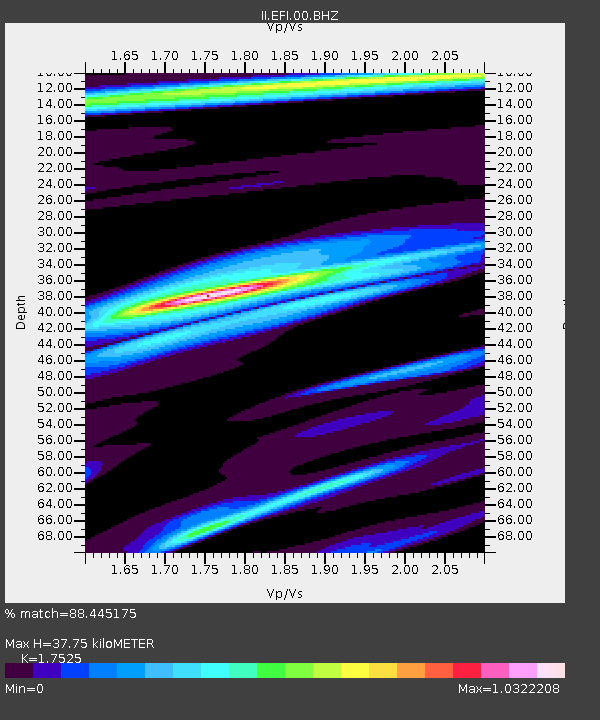
EFI Mount Kent, East Falkland Island - Earthquake Result Viewer

Earthquake location: Off E. Coast Of N. Island, N.Z.
Earthquake latitude/longitude: -39.0/178.3
Earthquake time(UTC): 2007/12/20 (354) 07:55:15 GMT
Earthquake Depth: 20 km
Earthquake Magnitude: 6.3 MB, 6.5 MS, 6.6 MW, 6.5 MW
Earthquake Catalog/Contributor: WHDF/NEIC
Network: II Global Seismograph Network (GSN - IRIS/IDA)
Station: EFI Mount Kent, East Falkland Island
Lat/Lon: 51.68 S/58.06 W
Elevation: 110 m
Distance: 77.2 deg
Az: 147.886 deg
Baz: 221.693 deg
Ray Param: 0.05047366
Estimated Moho Depth: 37.75 km
Estimated Crust Vp/Vs: 1.75
Assumed Crust Vp: 6.472 km/s
Estimated Crust Vs: 3.693 km/s
Estimated Crust Poisson's Ratio: 0.26
Radial Match: 88.445175 %
Radial Bump: 334
Transverse Match: 79.34981 %
Transverse Bump: 400
SOD ConfigId: 590571
Insert Time: 2013-09-26 17:53:28.242 +0000
GWidth: 2.5
Max Bumps: 400
Tol: 0.001

Signal To Noise

ChannelStoNSTALTA
II:EFI:00:BHZ:20071220T08:06:36.902988Z3.7636451.7492839E-64.647845E-7
II:EFI:00:BH1:20071220T08:06:36.902988Z1.39364454.0997517E-72.9417487E-7
II:EFI:00:BH2:20071220T08:06:36.902988Z1.75995544.064852E-72.3096337E-7
Arrivals
Ps4.5 SECOND
PpPs16 SECOND
PsPs/PpSs20 SECOND