You are here: Home > Network List > YB13 - Continental Dynamics/Cent. Anatolian Tectonics:Surface to Mantle Dynamics During Stations List
> Station AT34 Yesilkoy,Adana,Turkey > Earthquake Result Viewer
AT34 Yesilkoy,Adana,Turkey - Earthquake Result Viewer
| Earthquake location: |
Off East Coast Of Honshu, Japan |
| Earthquake latitude/longitude: |
41.0/143.2 |
| Earthquake time(UTC): |
2014/10/11 (284) 02:35:46 GMT |
| Earthquake Depth: |
14 km |
| Earthquake Magnitude: |
6.3 MWP |
| Earthquake Catalog/Contributor: |
NEIC PDE/NEIC COMCAT |
|
| Network: |
YB Continental Dynamics/Cent. Anatolian Tectonics:Surface to Mantle Dynamics During |
| Station: |
AT34 Yesilkoy,Adana,Turkey |
| Lat/Lon: |
37.91 N/35.51 E |
| Elevation: |
1097 m |
|
| Distance: |
77.4 deg |
| Az: |
309.459 deg |
| Baz: |
47.639 deg |
| Ray Param: |
0.050321866 |
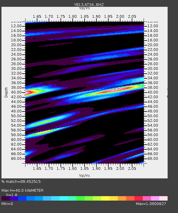
| Estimated Moho Depth: |
40.0 km |
| Estimated Crust Vp/Vs: |
1.60 |
| Assumed Crust Vp: |
6.247 km/s |
| Estimated Crust Vs: |
3.904 km/s |
| Estimated Crust Poisson's Ratio: |
0.18 |
|
| Radial Match: |
89.452515 % |
| Radial Bump: |
373 |
| Transverse Match: |
86.919174 % |
| Transverse Bump: |
400 |
| SOD ConfigId: |
3390531 |
| Insert Time: |
2019-04-14 11:46:16.601 +0000 |
| GWidth: |
2.5 |
| Max Bumps: |
400 |
| Tol: |
0.001 |
|

Signal To Noise
| Channel | StoN | STA | LTA |
| YB:AT34: :BHZ:20141011T02:47:09.339995Z | 24.10999 | 1.2332239E-6 | 5.1149915E-8 |
| YB:AT34: :BHN:20141011T02:47:09.339995Z | 14.164845 | 3.8816427E-7 | 2.7403354E-8 |
| YB:AT34: :BHE:20141011T02:47:09.339995Z | 7.9486527 | 2.6742194E-7 | 3.3643683E-8 |
| Arrivals |
| Ps | 4.0 SECOND |
| PpPs | 16 SECOND |
| PsPs/PpSs | 20 SECOND |


