You are here: Home > Network List > YB13 - Continental Dynamics/Cent. Anatolian Tectonics:Surface to Mantle Dynamics During Stations List
> Station AT48 Saylak,Hatay,Turkey > Earthquake Result Viewer
AT48 Saylak,Hatay,Turkey - Earthquake Result Viewer
| Earthquake location: |
Off East Coast Of Honshu, Japan |
| Earthquake latitude/longitude: |
41.0/143.2 |
| Earthquake time(UTC): |
2014/10/11 (284) 02:35:46 GMT |
| Earthquake Depth: |
14 km |
| Earthquake Magnitude: |
6.3 MWP |
| Earthquake Catalog/Contributor: |
NEIC PDE/NEIC COMCAT |
|
| Network: |
YB Continental Dynamics/Cent. Anatolian Tectonics:Surface to Mantle Dynamics During |
| Station: |
AT48 Saylak,Hatay,Turkey |
| Lat/Lon: |
36.62 N/36.41 E |
| Elevation: |
249 m |
|
| Distance: |
77.8 deg |
| Az: |
307.992 deg |
| Baz: |
47.866 deg |
| Ray Param: |
0.050095808 |
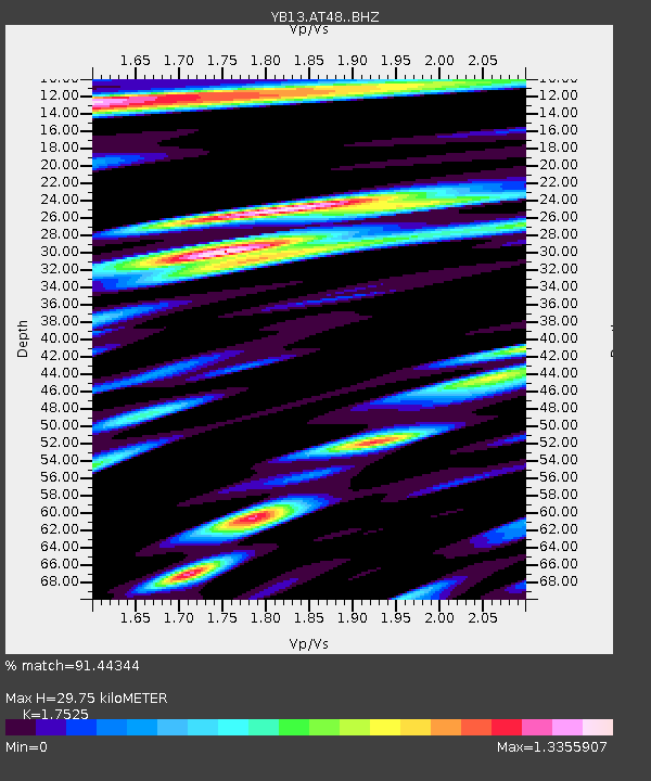
| Estimated Moho Depth: |
29.75 km |
| Estimated Crust Vp/Vs: |
1.75 |
| Assumed Crust Vp: |
6.247 km/s |
| Estimated Crust Vs: |
3.564 km/s |
| Estimated Crust Poisson's Ratio: |
0.26 |
|
| Radial Match: |
91.44344 % |
| Radial Bump: |
400 |
| Transverse Match: |
82.23191 % |
| Transverse Bump: |
400 |
| SOD ConfigId: |
3390531 |
| Insert Time: |
2019-04-14 11:46:23.673 +0000 |
| GWidth: |
2.5 |
| Max Bumps: |
400 |
| Tol: |
0.001 |
|

Signal To Noise
| Channel | StoN | STA | LTA |
| YB:AT48: :BHZ:20141011T02:47:11.19998Z | 8.6362915 | 1.8669592E-6 | 2.1617603E-7 |
| YB:AT48: :BHN:20141011T02:47:11.19998Z | 1.59246 | 4.3646858E-7 | 2.7408447E-7 |
| YB:AT48: :BHE:20141011T02:47:11.19998Z | 2.8741302 | 5.418482E-7 | 1.8852596E-7 |
| Arrivals |
| Ps | 3.7 SECOND |
| PpPs | 13 SECOND |
| PsPs/PpSs | 16 SECOND |


