You are here: Home > Network List > YB13 - Continental Dynamics/Cent. Anatolian Tectonics:Surface to Mantle Dynamics During Stations List
> Station AT54 "Alpu,Pozanti",Adana,Turkey > Earthquake Result Viewer
AT54 "Alpu,Pozanti",Adana,Turkey - Earthquake Result Viewer
| Earthquake location: |
Off East Coast Of Honshu, Japan |
| Earthquake latitude/longitude: |
41.0/143.2 |
| Earthquake time(UTC): |
2014/10/11 (284) 02:35:46 GMT |
| Earthquake Depth: |
14 km |
| Earthquake Magnitude: |
6.3 MWP |
| Earthquake Catalog/Contributor: |
NEIC PDE/NEIC COMCAT |
|
| Network: |
YB Continental Dynamics/Cent. Anatolian Tectonics:Surface to Mantle Dynamics During |
| Station: |
AT54 "Alpu,Pozanti",Adana,Turkey |
| Lat/Lon: |
37.48 N/34.88 E |
| Elevation: |
1154 m |
|
| Distance: |
78.1 deg |
| Az: |
309.483 deg |
| Baz: |
47.258 deg |
| Ray Param: |
0.049872488 |
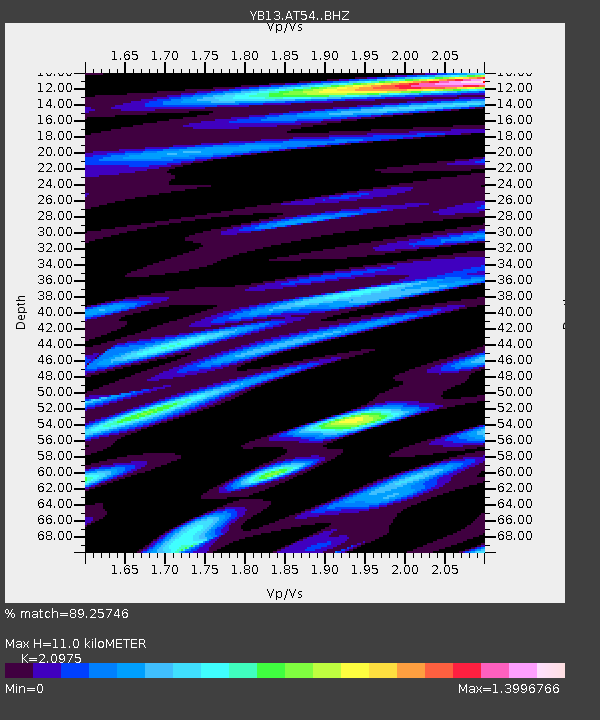
| Estimated Moho Depth: |
11.0 km |
| Estimated Crust Vp/Vs: |
2.10 |
| Assumed Crust Vp: |
6.247 km/s |
| Estimated Crust Vs: |
2.978 km/s |
| Estimated Crust Poisson's Ratio: |
0.35 |
|
| Radial Match: |
89.25746 % |
| Radial Bump: |
400 |
| Transverse Match: |
86.15904 % |
| Transverse Bump: |
400 |
| SOD ConfigId: |
3390531 |
| Insert Time: |
2019-04-14 11:46:27.235 +0000 |
| GWidth: |
2.5 |
| Max Bumps: |
400 |
| Tol: |
0.001 |
|

Signal To Noise
| Channel | StoN | STA | LTA |
| YB:AT54: :BHZ:20141011T02:47:13.000029Z | 26.19219 | 1.3495171E-6 | 5.1523646E-8 |
| YB:AT54: :BHN:20141011T02:47:13.000029Z | 7.9453864 | 3.6869366E-7 | 4.640349E-8 |
| YB:AT54: :BHE:20141011T02:47:13.000029Z | 5.75712 | 3.2207384E-7 | 5.594357E-8 |
| Arrivals |
| Ps | 2.0 SECOND |
| PpPs | 5.3 SECOND |
| PsPs/PpSs | 7.3 SECOND |


