You are here: Home > Network List > TA - USArray Transportable Network (new EarthScope stations) Stations List
> Station I23K Minto, Yukon-Koyukuk, AK, USA > Earthquake Result Viewer
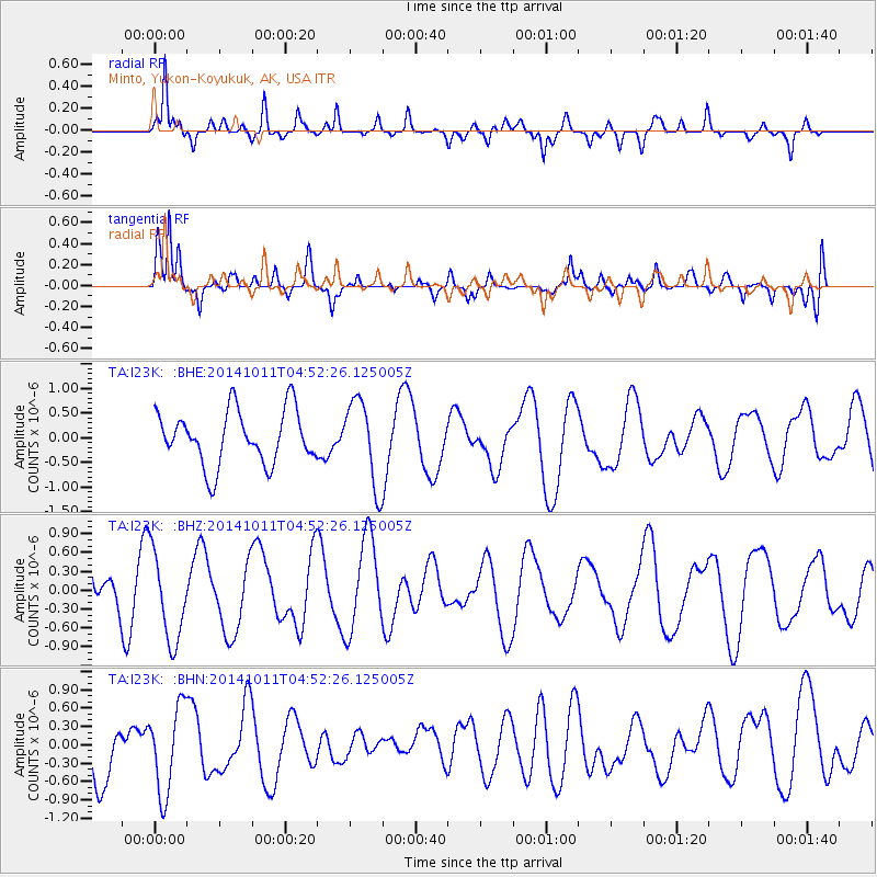
I23K Minto, Yukon-Koyukuk, AK, USA - Earthquake Result Viewer
*The percent match for this event was below the threshold and hence no stack was calculated.
| Earthquake location: |
Banda Sea |
| Earthquake latitude/longitude: |
-6.6/129.9 |
| Earthquake time(UTC): |
2014/10/11 (284) 04:40:05 GMT |
| Earthquake Depth: |
150 km |
| Earthquake Magnitude: |
4.8 mb |
| Earthquake Catalog/Contributor: |
ISC/ISC |
|
| Network: |
TA USArray Transportable Network (new EarthScope stations) |
| Station: |
I23K Minto, Yukon-Koyukuk, AK, USA |
| Lat/Lon: |
65.15 N/149.36 W |
| Elevation: |
149 m |
|
| Distance: |
92.1 deg |
| Az: |
24.673 deg |
| Baz: |
258.883 deg |
| Ray Param: |
$rayparam |
*The percent match for this event was below the threshold and hence was not used in the summary stack. |
|
| Radial Match: |
78.473625 % |
| Radial Bump: |
373 |
| Transverse Match: |
77.35915 % |
| Transverse Bump: |
400 |
| SOD ConfigId: |
3390531 |
| Insert Time: |
2019-04-14 11:50:05.924 +0000 |
| GWidth: |
2.5 |
| Max Bumps: |
400 |
| Tol: |
0.001 |
|
Signal To Noise
| Channel | StoN | STA | LTA |
| TA:I23K: :BHZ:20141011T04:52:26.125005Z | 2.8673098 | 7.1295085E-7 | 2.48648E-7 |
| TA:I23K: :BHN:20141011T04:52:26.125005Z | 1.6657379 | 7.002466E-7 | 4.2038224E-7 |
| TA:I23K: :BHE:20141011T04:52:26.125005Z | 1.5751 | 8.623249E-7 | 5.474732E-7 |
| Arrivals |
| Ps | |
| PpPs | |
| PsPs/PpSs | |


