You are here: Home > Network List > CI - Caltech Regional Seismic Network Stations List
> Station BAR Barrett, Tecate, CA, USA > Earthquake Result Viewer
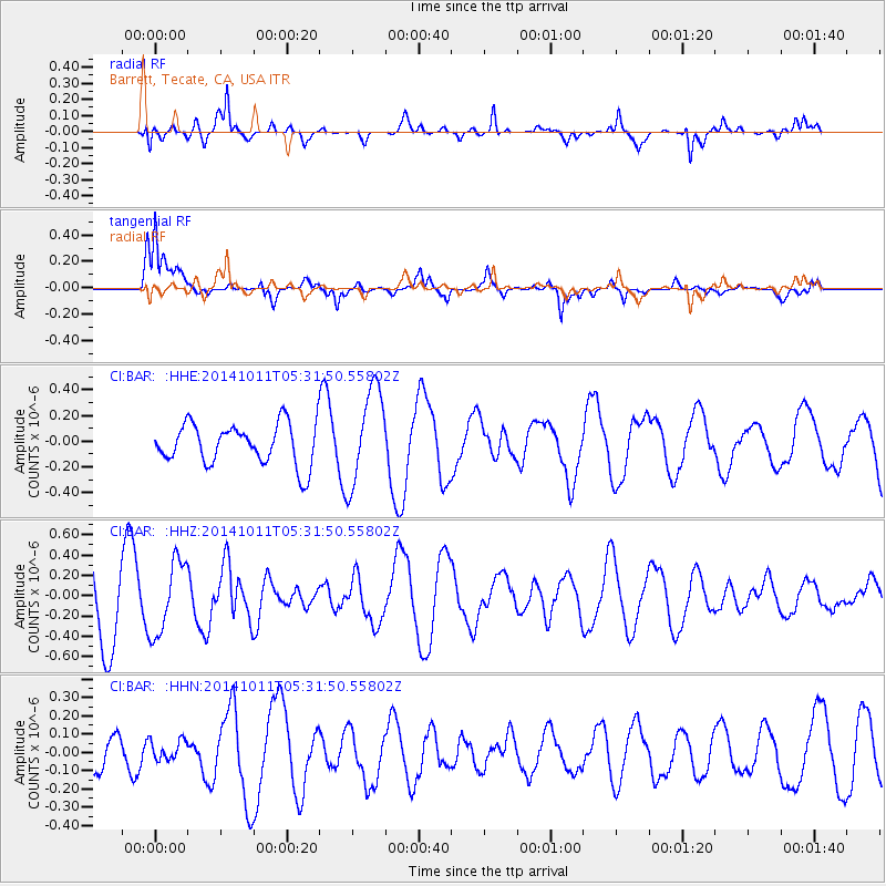
BAR Barrett, Tecate, CA, USA - Earthquake Result Viewer
*The percent match for this event was below the threshold and hence no stack was calculated.
| Earthquake location: |
Near East Coast Of Honshu, Japan |
| Earthquake latitude/longitude: |
41.0/143.0 |
| Earthquake time(UTC): |
2014/10/11 (284) 05:20:37 GMT |
| Earthquake Depth: |
35 km |
| Earthquake Magnitude: |
5.5 MB |
| Earthquake Catalog/Contributor: |
NEIC PDE/NEIC COMCAT |
|
| Network: |
CI Caltech Regional Seismic Network |
| Station: |
BAR Barrett, Tecate, CA, USA |
| Lat/Lon: |
32.68 N/116.67 W |
| Elevation: |
521 m |
|
| Distance: |
76.3 deg |
| Az: |
58.631 deg |
| Baz: |
309.944 deg |
| Ray Param: |
$rayparam |
*The percent match for this event was below the threshold and hence was not used in the summary stack. |
|
| Radial Match: |
62.17411 % |
| Radial Bump: |
350 |
| Transverse Match: |
82.9429 % |
| Transverse Bump: |
400 |
| SOD ConfigId: |
3390531 |
| Insert Time: |
2019-04-14 11:52:52.775 +0000 |
| GWidth: |
2.5 |
| Max Bumps: |
400 |
| Tol: |
0.001 |
|
Signal To Noise
| Channel | StoN | STA | LTA |
| CI:BAR: :HHZ:20141011T05:31:50.55802Z | 1.0157409 | 3.5775724E-7 | 3.522131E-7 |
| CI:BAR: :HHN:20141011T05:31:50.55802Z | 0.36302832 | 5.317843E-8 | 1.4648562E-7 |
| CI:BAR: :HHE:20141011T05:31:50.55802Z | 1.7833579 | 3.4516142E-7 | 1.9354579E-7 |
| Arrivals |
| Ps | |
| PpPs | |
| PsPs/PpSs | |


