You are here: Home > Network List > KN - Kyrgyz Seismic Telemetry Network Stations List
> Station TKM2 - > Earthquake Result Viewer
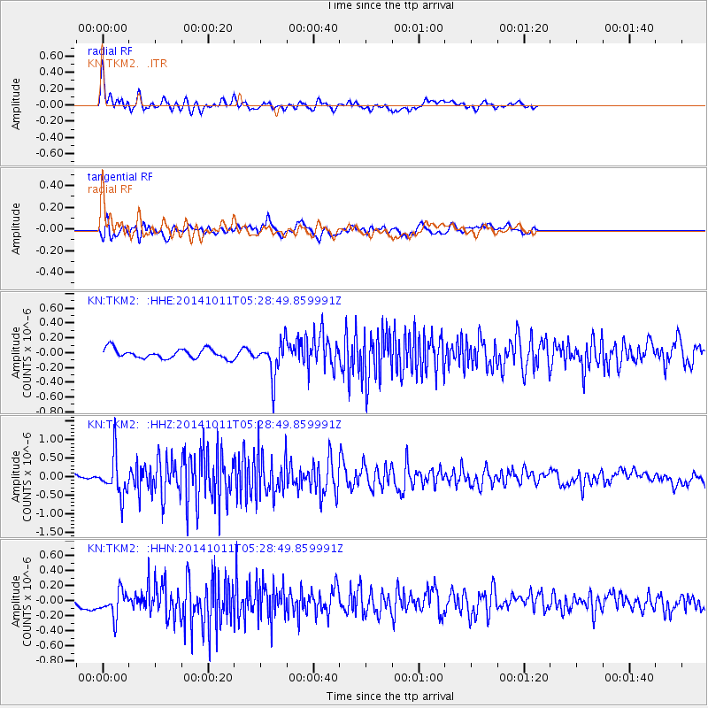
TKM2 - - Earthquake Result Viewer
*The percent match for this event was below the threshold and hence no stack was calculated.
| Earthquake location: |
Near East Coast Of Honshu, Japan |
| Earthquake latitude/longitude: |
41.0/143.0 |
| Earthquake time(UTC): |
2014/10/11 (284) 05:20:37 GMT |
| Earthquake Depth: |
35 km |
| Earthquake Magnitude: |
5.5 MB |
| Earthquake Catalog/Contributor: |
NEIC PDE/NEIC COMCAT |
|
| Network: |
KN Kyrgyz Seismic Telemetry Network |
| Station: |
TKM2 - |
| Lat/Lon: |
42.92 N/75.60 E |
| Elevation: |
2020 m |
|
| Distance: |
48.9 deg |
| Az: |
295.906 deg |
| Baz: |
68.014 deg |
| Ray Param: |
$rayparam |
*The percent match for this event was below the threshold and hence was not used in the summary stack. |
|
| Radial Match: |
72.89249 % |
| Radial Bump: |
400 |
| Transverse Match: |
67.13673 % |
| Transverse Bump: |
400 |
| SOD ConfigId: |
3390531 |
| Insert Time: |
2019-04-14 11:54:34.582 +0000 |
| GWidth: |
2.5 |
| Max Bumps: |
400 |
| Tol: |
0.001 |
|
Signal To Noise
| Channel | StoN | STA | LTA |
| KN:TKM2: :HHZ:20141011T05:28:49.859991Z | 6.610234 | 5.4544574E-7 | 8.251535E-8 |
| KN:TKM2: :HHN:20141011T05:28:49.859991Z | 2.646717 | 1.716296E-7 | 6.484622E-8 |
| KN:TKM2: :HHE:20141011T05:28:49.859991Z | 3.825652 | 2.5029738E-7 | 6.542607E-8 |
| Arrivals |
| Ps | |
| PpPs | |
| PsPs/PpSs | |


