You are here: Home > Network List > IU - Global Seismograph Network (GSN - IRIS/USGS) Stations List
> Station RSSD Black Hills, South Dakota, USA > Earthquake Result Viewer
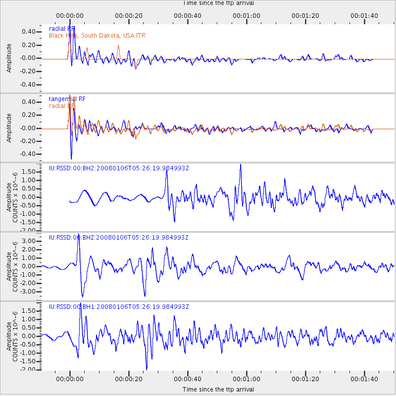
RSSD Black Hills, South Dakota, USA - Earthquake Result Viewer
*The percent match for this event was below the threshold and hence no stack was calculated.
| Earthquake location: |
Southern Greece |
| Earthquake latitude/longitude: |
37.2/22.7 |
| Earthquake time(UTC): |
2008/01/06 (006) 05:14:20 GMT |
| Earthquake Depth: |
75 km |
| Earthquake Magnitude: |
6.1 MB, 6.2 MW, 6.1 MW |
| Earthquake Catalog/Contributor: |
WHDF/NEIC |
|
| Network: |
IU Global Seismograph Network (GSN - IRIS/USGS) |
| Station: |
RSSD Black Hills, South Dakota, USA |
| Lat/Lon: |
44.12 N/104.04 W |
| Elevation: |
2060 m |
|
| Distance: |
85.8 deg |
| Az: |
324.633 deg |
| Baz: |
39.91 deg |
| Ray Param: |
$rayparam |
*The percent match for this event was below the threshold and hence was not used in the summary stack. |
|
| Radial Match: |
83.69569 % |
| Radial Bump: |
400 |
| Transverse Match: |
67.4141 % |
| Transverse Bump: |
400 |
| SOD ConfigId: |
590571 |
| Insert Time: |
2013-09-26 18:39:07.860 +0000 |
| GWidth: |
2.5 |
| Max Bumps: |
400 |
| Tol: |
0.001 |
|
Signal To Noise
| Channel | StoN | STA | LTA |
| IU:RSSD:00:BHZ:20080106T05:26:19.984993Z | 7.428552 | 1.8357055E-6 | 2.4711485E-7 |
| IU:RSSD:00:BH1:20080106T05:26:19.984993Z | 4.5998063 | 7.6622155E-7 | 1.6657691E-7 |
| IU:RSSD:00:BH2:20080106T05:26:19.984993Z | 2.5813987 | 5.629774E-7 | 2.1809007E-7 |
| Arrivals |
| Ps | |
| PpPs | |
| PsPs/PpSs | |


