You are here: Home > Network List > II - Global Seismograph Network (GSN - IRIS/IDA) Stations List
> Station JTS Las Juntas de Abangares, Costa Rica > Earthquake Result Viewer
JTS Las Juntas de Abangares, Costa Rica - Earthquake Result Viewer
| Earthquake location: |
Tonga Islands |
| Earthquake latitude/longitude: |
-15.3/-173.5 |
| Earthquake time(UTC): |
2003/03/28 (087) 17:31:47 GMT |
| Earthquake Depth: |
41 km |
| Earthquake Magnitude: |
5.8 MB, 6.0 MS, 6.2 MW, 6.1 MW |
| Earthquake Catalog/Contributor: |
WHDF/NEIC |
|
| Network: |
II Global Seismograph Network (GSN - IRIS/IDA) |
| Station: |
JTS Las Juntas de Abangares, Costa Rica |
| Lat/Lon: |
10.29 N/84.95 W |
| Elevation: |
340 m |
|
| Distance: |
91.3 deg |
| Az: |
79.757 deg |
| Baz: |
254.761 deg |
| Ray Param: |
0.04160618 |
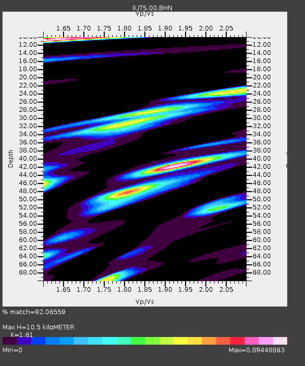
| Estimated Moho Depth: |
10.5 km |
| Estimated Crust Vp/Vs: |
1.61 |
| Assumed Crust Vp: |
6.597 km/s |
| Estimated Crust Vs: |
4.098 km/s |
| Estimated Crust Poisson's Ratio: |
0.19 |
|
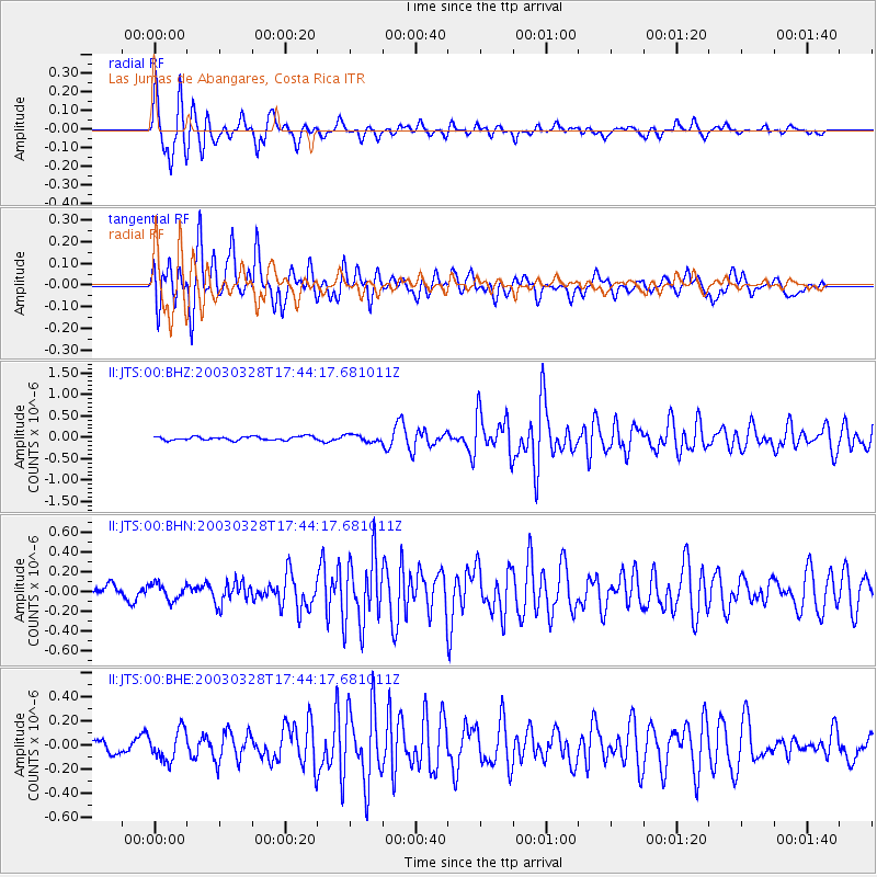
| Radial Match: |
92.06559 % |
| Radial Bump: |
400 |
| Transverse Match: |
86.400826 % |
| Transverse Bump: |
400 |
| SOD ConfigId: |
4714 |
| Insert Time: |
2010-03-01 15:13:10.528 +0000 |
| GWidth: |
2.5 |
| Max Bumps: |
400 |
| Tol: |
0.001 |
|
Signal To Noise
| Channel | StoN | STA | LTA |
| II:JTS:00:BHN:20030328T17:44:17.681011Z | 1.0523366 | 8.215427E-8 | 7.806844E-8 |
| II:JTS:00:BHE:20030328T17:44:17.681011Z | 2.7262464 | 1.2532915E-7 | 4.5971326E-8 |
| II:JTS:00:BHZ:20030328T17:44:17.681011Z | 1.9361416 | 8.0967666E-8 | 4.181908E-8 |
| Arrivals |
| Ps | 1.0 SECOND |
| PpPs | 4.1 SECOND |
| PsPs/PpSs | 5.0 SECOND |


