You are here: Home > Network List > IU - Global Seismograph Network (GSN - IRIS/USGS) Stations List
> Station RSSD Black Hills, South Dakota, USA > Earthquake Result Viewer
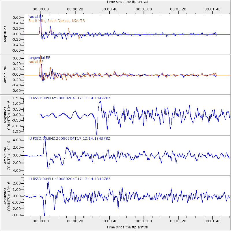
RSSD Black Hills, South Dakota, USA - Earthquake Result Viewer
*The percent match for this event was below the threshold and hence no stack was calculated.
| Earthquake location: |
Near Coast Of Northern Chile |
| Earthquake latitude/longitude: |
-20.2/-70.0 |
| Earthquake time(UTC): |
2008/02/04 (035) 17:01:30 GMT |
| Earthquake Depth: |
44 km |
| Earthquake Magnitude: |
6.0 MB, 6.2 MS, 6.3 MW, 6.3 MW |
| Earthquake Catalog/Contributor: |
WHDF/NEIC |
|
| Network: |
IU Global Seismograph Network (GSN - IRIS/USGS) |
| Station: |
RSSD Black Hills, South Dakota, USA |
| Lat/Lon: |
44.12 N/104.04 W |
| Elevation: |
2060 m |
|
| Distance: |
71.1 deg |
| Az: |
334.814 deg |
| Baz: |
146.282 deg |
| Ray Param: |
$rayparam |
*The percent match for this event was below the threshold and hence was not used in the summary stack. |
|
| Radial Match: |
85.1388 % |
| Radial Bump: |
400 |
| Transverse Match: |
86.10712 % |
| Transverse Bump: |
400 |
| SOD ConfigId: |
590571 |
| Insert Time: |
2013-09-26 19:31:31.105 +0000 |
| GWidth: |
2.5 |
| Max Bumps: |
400 |
| Tol: |
0.001 |
|
Signal To Noise
| Channel | StoN | STA | LTA |
| IU:RSSD:00:BHZ:20080204T17:12:14.134978Z | 31.333418 | 2.3461662E-6 | 7.487744E-8 |
| IU:RSSD:00:BH1:20080204T17:12:14.134978Z | 6.5020614 | 1.3264561E-6 | 2.0400546E-7 |
| IU:RSSD:00:BH2:20080204T17:12:14.134978Z | 5.243208 | 8.3590754E-7 | 1.5942675E-7 |
| Arrivals |
| Ps | |
| PpPs | |
| PsPs/PpSs | |


