You are here: Home > Network List > US - United States National Seismic Network Stations List
> Station KSU1 Kansas State University--Konza Prairie, Kansas, USA > Earthquake Result Viewer
KSU1 Kansas State University--Konza Prairie, Kansas, USA - Earthquake Result Viewer
| Earthquake location: |
Northern Mid-Atlantic Ridge |
| Earthquake latitude/longitude: |
10.7/-41.9 |
| Earthquake time(UTC): |
2008/02/08 (039) 09:38:14 GMT |
| Earthquake Depth: |
9.0 km |
| Earthquake Magnitude: |
6.9 MW, 6.4 MB, 6.9 MW, 6.9 MS |
| Earthquake Catalog/Contributor: |
NEIC PDE/NEIC PDE-M |
|
| Network: |
US United States National Seismic Network |
| Station: |
KSU1 Kansas State University--Konza Prairie, Kansas, USA |
| Lat/Lon: |
39.10 N/96.61 W |
| Elevation: |
347 m |
|
| Distance: |
56.1 deg |
| Az: |
310.094 deg |
| Baz: |
104.904 deg |
| Ray Param: |
0.06434917 |
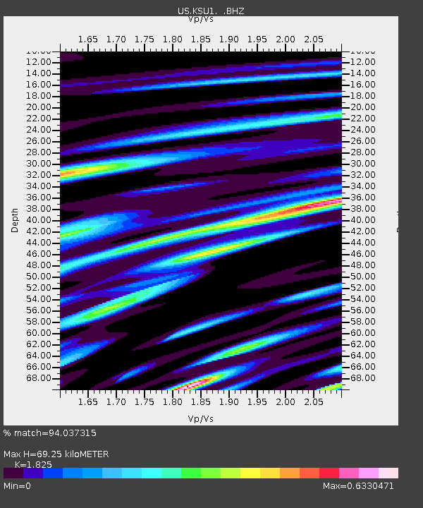
| Estimated Moho Depth: |
69.25 km |
| Estimated Crust Vp/Vs: |
1.83 |
| Assumed Crust Vp: |
6.483 km/s |
| Estimated Crust Vs: |
3.552 km/s |
| Estimated Crust Poisson's Ratio: |
0.29 |
|
| Radial Match: |
94.037315 % |
| Radial Bump: |
353 |
| Transverse Match: |
79.17606 % |
| Transverse Bump: |
400 |
| SOD ConfigId: |
590571 |
| Insert Time: |
2013-09-26 19:38:07.593 +0000 |
| GWidth: |
2.5 |
| Max Bumps: |
400 |
| Tol: |
0.001 |
|
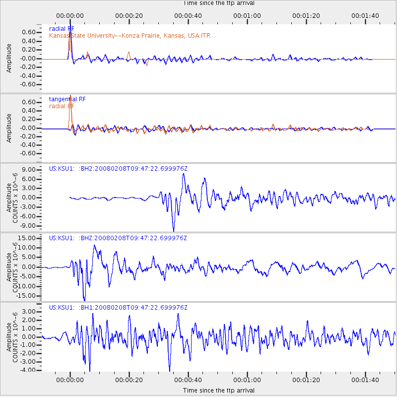
Signal To Noise
| Channel | StoN | STA | LTA |
| US:KSU1: :BHZ:20080208T09:47:22.699976Z | 23.89269 | 5.535117E-6 | 2.316657E-7 |
| US:KSU1: :BH1:20080208T09:47:22.699976Z | 4.220924 | 9.887794E-7 | 2.3425666E-7 |
| US:KSU1: :BH2:20080208T09:47:22.699976Z | 10.212375 | 2.37794E-6 | 2.3284888E-7 |
| Arrivals |
| Ps | 9.3 SECOND |
| PpPs | 29 SECOND |
| PsPs/PpSs | 38 SECOND |


