You are here: Home > Network List > CI - Caltech Regional Seismic Network Stations List
> Station TIN Tinemaha, California, USA > Earthquake Result Viewer
TIN Tinemaha, California, USA - Earthquake Result Viewer
| Earthquake location: |
Near Coast Of Peru |
| Earthquake latitude/longitude: |
-17.7/-71.6 |
| Earthquake time(UTC): |
2001/06/26 (177) 04:18:31 GMT |
| Earthquake Depth: |
24 km |
| Earthquake Magnitude: |
6.2 MB, 6.7 MS, 6.8 MW, 6.7 ME |
| Earthquake Catalog/Contributor: |
WHDF/NEIC |
|
| Network: |
CI Caltech Regional Seismic Network |
| Station: |
TIN Tinemaha, California, USA |
| Lat/Lon: |
37.05 N/118.23 W |
| Elevation: |
1164 m |
|
| Distance: |
70.0 deg |
| Az: |
321.798 deg |
| Baz: |
132.547 deg |
| Ray Param: |
0.055254214 |
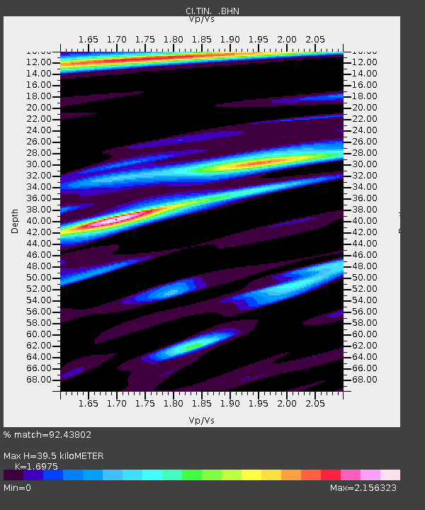
| Estimated Moho Depth: |
39.5 km |
| Estimated Crust Vp/Vs: |
1.70 |
| Assumed Crust Vp: |
6.291 km/s |
| Estimated Crust Vs: |
3.706 km/s |
| Estimated Crust Poisson's Ratio: |
0.23 |
|
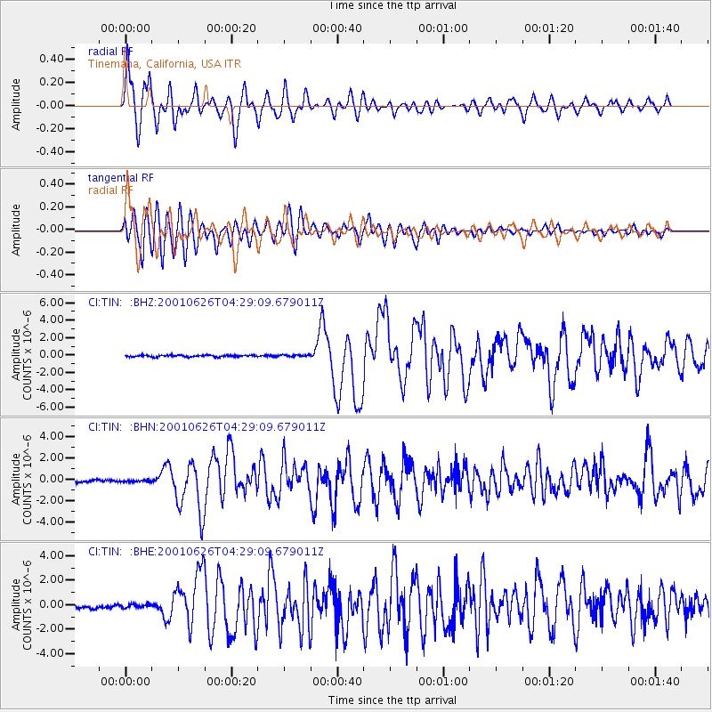
| Radial Match: |
92.43802 % |
| Radial Bump: |
400 |
| Transverse Match: |
86.4521 % |
| Transverse Bump: |
400 |
| SOD ConfigId: |
3770 |
| Insert Time: |
2010-02-25 20:46:10.755 +0000 |
| GWidth: |
2.5 |
| Max Bumps: |
400 |
| Tol: |
0.001 |
|
Signal To Noise
| Channel | StoN | STA | LTA |
| CI:TIN: :BHN:20010626T04:29:09.679011Z | 0.49751908 | 8.356703E-8 | 1.6796749E-7 |
| CI:TIN: :BHE:20010626T04:29:09.679011Z | 1.0922147 | 1.7198006E-7 | 1.5745994E-7 |
| CI:TIN: :BHZ:20010626T04:29:09.679011Z | 1.1222684 | 1.0582464E-7 | 9.429531E-8 |
| Arrivals |
| Ps | 4.5 SECOND |
| PpPs | 16 SECOND |
| PsPs/PpSs | 21 SECOND |


