You are here: Home > Network List > II - Global Seismograph Network (GSN - IRIS/IDA) Stations List
> Station MSEY Mahe, Seychelles > Earthquake Result Viewer
MSEY Mahe, Seychelles - Earthquake Result Viewer
| Earthquake location: |
Southern Greece |
| Earthquake latitude/longitude: |
36.5/21.7 |
| Earthquake time(UTC): |
2008/02/14 (045) 10:09:22 GMT |
| Earthquake Depth: |
29 km |
| Earthquake Magnitude: |
6.9 MW, 6.2 MB, 6.6 MS, 6.7 MW |
| Earthquake Catalog/Contributor: |
NEIC PDE/NEIC PDE-M |
|
| Network: |
II Global Seismograph Network (GSN - IRIS/IDA) |
| Station: |
MSEY Mahe, Seychelles |
| Lat/Lon: |
4.67 S/55.48 E |
| Elevation: |
475 m |
|
| Distance: |
51.7 deg |
| Az: |
135.057 deg |
| Baz: |
325.176 deg |
| Ray Param: |
0.067170344 |
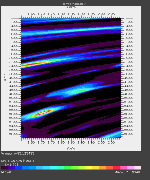
| Estimated Moho Depth: |
57.25 km |
| Estimated Crust Vp/Vs: |
1.71 |
| Assumed Crust Vp: |
6.303 km/s |
| Estimated Crust Vs: |
3.696 km/s |
| Estimated Crust Poisson's Ratio: |
0.24 |
|
| Radial Match: |
85.125435 % |
| Radial Bump: |
400 |
| Transverse Match: |
61.218304 % |
| Transverse Bump: |
400 |
| SOD ConfigId: |
590571 |
| Insert Time: |
2013-09-26 19:47:51.596 +0000 |
| GWidth: |
2.5 |
| Max Bumps: |
400 |
| Tol: |
0.001 |
|

Signal To Noise
| Channel | StoN | STA | LTA |
| II:MSEY:00:BHZ:20080214T10:17:56.618987Z | 2.4990537 | 2.5212632E-6 | 1.0088871E-6 |
| II:MSEY:00:BH1:20080214T10:17:56.618987Z | 0.5409189 | 6.149007E-7 | 1.1367707E-6 |
| II:MSEY:00:BH2:20080214T10:17:56.618987Z | 1.9792914 | 1.4839536E-6 | 7.497398E-7 |
| Arrivals |
| Ps | 6.8 SECOND |
| PpPs | 23 SECOND |
| PsPs/PpSs | 30 SECOND |


