You are here: Home > Network List > II - Global Seismograph Network (GSN - IRIS/IDA) Stations List
> Station PALK Pallekele, Sri Lanka > Earthquake Result Viewer
PALK Pallekele, Sri Lanka - Earthquake Result Viewer
| Earthquake location: |
Southern Greece |
| Earthquake latitude/longitude: |
36.5/21.7 |
| Earthquake time(UTC): |
2008/02/14 (045) 10:09:22 GMT |
| Earthquake Depth: |
29 km |
| Earthquake Magnitude: |
6.9 MW, 6.2 MB, 6.6 MS, 6.7 MW |
| Earthquake Catalog/Contributor: |
NEIC PDE/NEIC PDE-M |
|
| Network: |
II Global Seismograph Network (GSN - IRIS/IDA) |
| Station: |
PALK Pallekele, Sri Lanka |
| Lat/Lon: |
7.27 N/80.70 E |
| Elevation: |
460 m |
|
| Distance: |
60.9 deg |
| Az: |
103.294 deg |
| Baz: |
307.774 deg |
| Ray Param: |
0.061157458 |
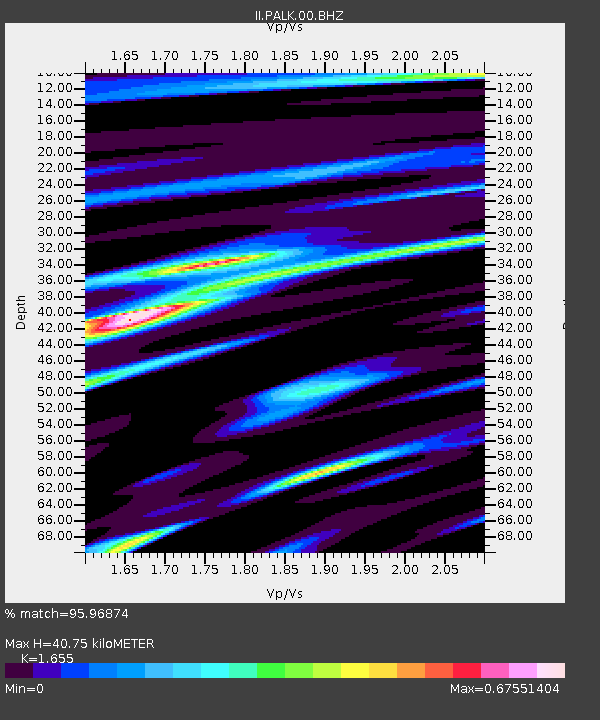
| Estimated Moho Depth: |
40.75 km |
| Estimated Crust Vp/Vs: |
1.65 |
| Assumed Crust Vp: |
6.545 km/s |
| Estimated Crust Vs: |
3.955 km/s |
| Estimated Crust Poisson's Ratio: |
0.21 |
|
| Radial Match: |
95.96874 % |
| Radial Bump: |
369 |
| Transverse Match: |
93.96456 % |
| Transverse Bump: |
400 |
| SOD ConfigId: |
590571 |
| Insert Time: |
2013-09-26 19:47:52.299 +0000 |
| GWidth: |
2.5 |
| Max Bumps: |
400 |
| Tol: |
0.001 |
|
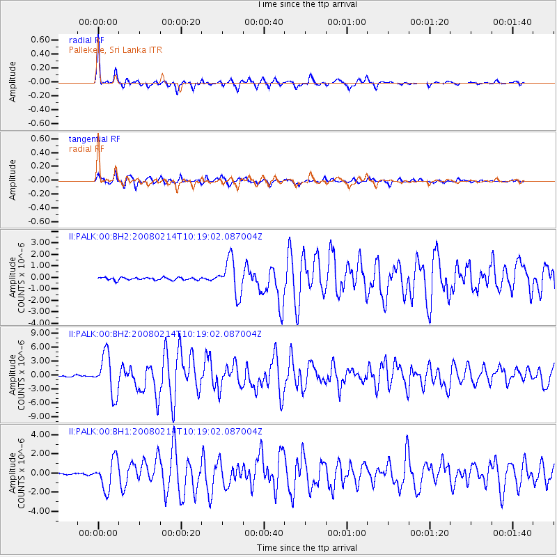
Signal To Noise
| Channel | StoN | STA | LTA |
| II:PALK:00:BHZ:20080214T10:19:02.087004Z | 34.187176 | 4.48005E-6 | 1.3104474E-7 |
| II:PALK:00:BH1:20080214T10:19:02.087004Z | 15.3410225 | 1.6191593E-6 | 1.05544416E-7 |
| II:PALK:00:BH2:20080214T10:19:02.087004Z | 14.625902 | 1.5899503E-6 | 1.08707845E-7 |
| Arrivals |
| Ps | 4.3 SECOND |
| PpPs | 16 SECOND |
| PsPs/PpSs | 20 SECOND |


