You are here: Home > Network List > II - Global Seismograph Network (GSN - IRIS/IDA) Stations List
> Station MSEY Mahe, Seychelles > Earthquake Result Viewer
MSEY Mahe, Seychelles - Earthquake Result Viewer
| Earthquake location: |
Southern Greece |
| Earthquake latitude/longitude: |
36.3/21.8 |
| Earthquake time(UTC): |
2008/02/20 (051) 18:27:06 GMT |
| Earthquake Depth: |
9.9 km |
| Earthquake Magnitude: |
5.7 MB, 6.1 MS, 6.1 MW, 6.1 MW |
| Earthquake Catalog/Contributor: |
WHDF/NEIC |
|
| Network: |
II Global Seismograph Network (GSN - IRIS/IDA) |
| Station: |
MSEY Mahe, Seychelles |
| Lat/Lon: |
4.67 S/55.48 E |
| Elevation: |
475 m |
|
| Distance: |
51.5 deg |
| Az: |
135.047 deg |
| Baz: |
325.061 deg |
| Ray Param: |
0.067362204 |
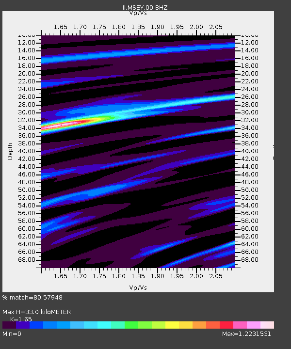
| Estimated Moho Depth: |
33.0 km |
| Estimated Crust Vp/Vs: |
1.65 |
| Assumed Crust Vp: |
6.303 km/s |
| Estimated Crust Vs: |
3.82 km/s |
| Estimated Crust Poisson's Ratio: |
0.21 |
|
| Radial Match: |
80.57948 % |
| Radial Bump: |
314 |
| Transverse Match: |
51.47936 % |
| Transverse Bump: |
400 |
| SOD ConfigId: |
590571 |
| Insert Time: |
2013-09-26 20:01:37.569 +0000 |
| GWidth: |
2.5 |
| Max Bumps: |
400 |
| Tol: |
0.001 |
|
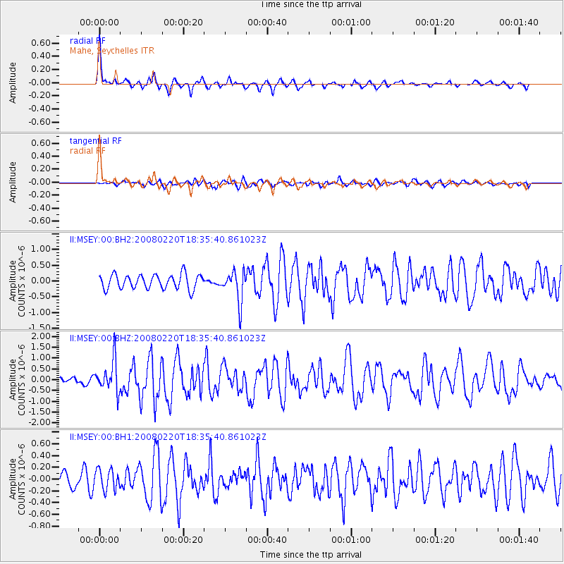
Signal To Noise
| Channel | StoN | STA | LTA |
| II:MSEY:00:BHZ:20080220T18:35:40.861023Z | 4.9675293 | 7.486926E-7 | 1.5071731E-7 |
| II:MSEY:00:BH1:20080220T18:35:40.861023Z | 0.7983552 | 1.7789151E-7 | 2.2282251E-7 |
| II:MSEY:00:BH2:20080220T18:35:40.861023Z | 2.2168937 | 5.0947114E-7 | 2.2981307E-7 |
| Arrivals |
| Ps | 3.6 SECOND |
| PpPs | 13 SECOND |
| PsPs/PpSs | 17 SECOND |


