You are here: Home > Network List > KZ - Kazakhstan Network Stations List
> Station KUR21 Cross-array, Kurchatov, Kazakstan > Earthquake Result Viewer
KUR21 Cross-array, Kurchatov, Kazakstan - Earthquake Result Viewer
| Earthquake location: |
Southern Greece |
| Earthquake latitude/longitude: |
36.3/21.8 |
| Earthquake time(UTC): |
2008/02/20 (051) 18:27:06 GMT |
| Earthquake Depth: |
9.9 km |
| Earthquake Magnitude: |
5.7 MB, 6.1 MS, 6.1 MW, 6.1 MW |
| Earthquake Catalog/Contributor: |
WHDF/NEIC |
|
| Network: |
KZ Kazakhstan Network |
| Station: |
KUR21 Cross-array, Kurchatov, Kazakstan |
| Lat/Lon: |
50.62 N/78.53 E |
| Elevation: |
200 m |
|
| Distance: |
42.6 deg |
| Az: |
51.943 deg |
| Baz: |
272.873 deg |
| Ray Param: |
0.07309558 |
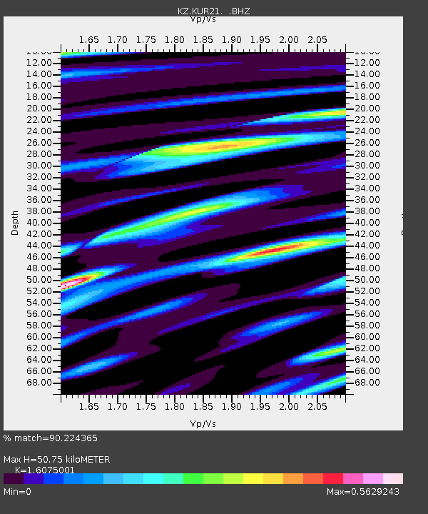
| Estimated Moho Depth: |
50.75 km |
| Estimated Crust Vp/Vs: |
1.61 |
| Assumed Crust Vp: |
6.552 km/s |
| Estimated Crust Vs: |
4.076 km/s |
| Estimated Crust Poisson's Ratio: |
0.18 |
|
| Radial Match: |
90.224365 % |
| Radial Bump: |
318 |
| Transverse Match: |
91.55241 % |
| Transverse Bump: |
400 |
| SOD ConfigId: |
590571 |
| Insert Time: |
2013-09-26 20:01:56.751 +0000 |
| GWidth: |
2.5 |
| Max Bumps: |
400 |
| Tol: |
0.001 |
|

Signal To Noise
| Channel | StoN | STA | LTA |
| KZ:KUR21: :BHZ:20080220T18:34:31.125Z | 8.990524 | 6.251801E-7 | 6.953768E-8 |
| KZ:KUR21: :BH1:20080220T18:34:31.125Z | 7.2525973 | 2.6073184E-7 | 3.5950134E-8 |
| KZ:KUR21: :BH2:20080220T18:34:31.125Z | 4.6674943 | 1.7939482E-7 | 3.843493E-8 |
| Arrivals |
| Ps | 5.1 SECOND |
| PpPs | 19 SECOND |
| PsPs/PpSs | 24 SECOND |


