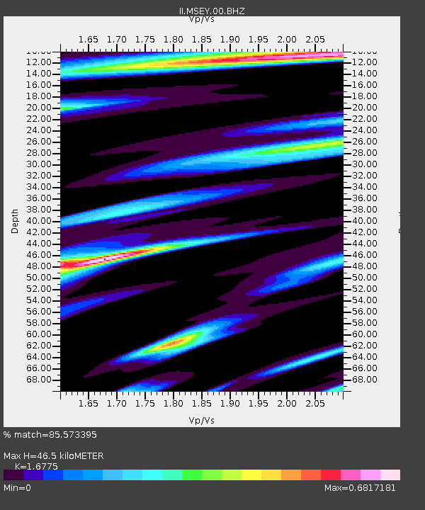
MSEY Mahe, Seychelles - Earthquake Result Viewer

Earthquake location: South Sandwich Islands Region
Earthquake latitude/longitude: -57.3/-23.4
Earthquake time(UTC): 2008/02/23 (054) 15:57:19 GMT
Earthquake Depth: 10 km
Earthquake Magnitude: 6.2 MB, 6.7 MS, 6.7 MW, 6.7 MW
Earthquake Catalog/Contributor: WHDF/NEIC
Network: II Global Seismograph Network (GSN - IRIS/IDA)
Station: MSEY Mahe, Seychelles
Lat/Lon: 4.67 S/55.48 E
Elevation: 475 m
Distance: 80.1 deg
Az: 83.161 deg
Baz: 212.707 deg
Ray Param: 0.048513617
Estimated Moho Depth: 46.5 km
Estimated Crust Vp/Vs: 1.68
Assumed Crust Vp: 6.303 km/s
Estimated Crust Vs: 3.757 km/s
Estimated Crust Poisson's Ratio: 0.22
Radial Match: 85.573395 %
Radial Bump: 400
Transverse Match: 67.2119 %
Transverse Bump: 400
SOD ConfigId: 590571
Insert Time: 2013-09-26 20:09:42.901 +0000
GWidth: 2.5
Max Bumps: 400
Tol: 0.001

Signal To Noise

ChannelStoNSTALTA
II:MSEY:00:BHZ:20080223T16:08:58.385989Z9.2371911.634837E-61.769842E-7
II:MSEY:00:BH1:20080223T16:08:58.385989Z4.2980695.923958E-71.3782837E-7
II:MSEY:00:BH2:20080223T16:08:58.385989Z2.06896423.7621507E-71.818374E-7
Arrivals
Ps5.1 SECOND
PpPs19 SECOND
PsPs/PpSs24 SECOND