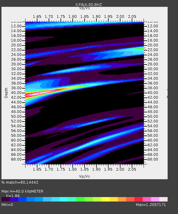
PALK Pallekele, Sri Lanka - Earthquake Result Viewer
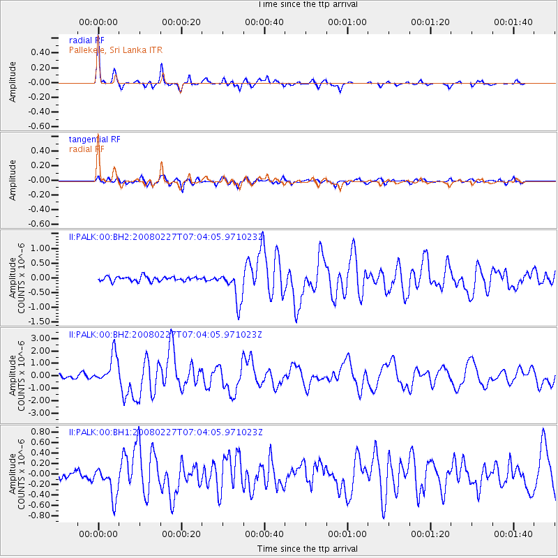
Earthquake location: Bonin Islands, Japan Region
Earthquake latitude/longitude: 26.8/142.4
Earthquake time(UTC): 2008/02/27 (058) 06:54:20 GMT
Earthquake Depth: 15 km
Earthquake Magnitude: 5.8 MB, 6.1 MS, 6.2 MW, 6.2 MW
Earthquake Catalog/Contributor: WHDF/NEIC
Network: II Global Seismograph Network (GSN - IRIS/IDA)
Station: PALK Pallekele, Sri Lanka
Lat/Lon: 7.27 N/80.70 E
Elevation: 460 m
Distance: 61.6 deg
Az: 263.574 deg
Baz: 63.53 deg
Ray Param: 0.060785893
Estimated Moho Depth: 40.0 km
Estimated Crust Vp/Vs: 1.66
Assumed Crust Vp: 6.545 km/s
Estimated Crust Vs: 3.943 km/s
Estimated Crust Poisson's Ratio: 0.22
Radial Match: 90.14442 %
Radial Bump: 311
Transverse Match: 84.80785 %
Transverse Bump: 400
SOD ConfigId: 590571
Insert Time: 2013-09-26 20:18:38.389 +0000
GWidth: 2.5
Max Bumps: 400
Tol: 0.001

Signal To Noise

ChannelStoNSTALTA
II:PALK:00:BHZ:20080227T07:04:05.971023Z7.68459751.2307945E-61.6016382E-7
II:PALK:00:BH1:20080227T07:04:05.971023Z3.15744263.0855264E-79.772233E-8
II:PALK:00:BH2:20080227T07:04:05.971023Z7.3939455.58361E-77.551598E-8
Arrivals
Ps4.2 SECOND
PpPs15 SECOND
PsPs/PpSs20 SECOND