You are here: Home > Network List > IU - Global Seismograph Network (GSN - IRIS/USGS) Stations List
> Station RSSD Black Hills, South Dakota, USA > Earthquake Result Viewer
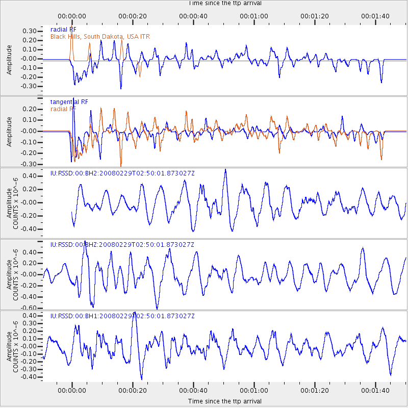
RSSD Black Hills, South Dakota, USA - Earthquake Result Viewer
*The percent match for this event was below the threshold and hence no stack was calculated.
| Earthquake location: |
Southern East Pacific Rise |
| Earthquake latitude/longitude: |
-35.1/-109.0 |
| Earthquake time(UTC): |
2008/02/29 (060) 02:38:29 GMT |
| Earthquake Depth: |
10 km |
| Earthquake Magnitude: |
5.7 MW, 5.7 MW |
| Earthquake Catalog/Contributor: |
NEIC PDE/NEIC PDE-M |
|
| Network: |
IU Global Seismograph Network (GSN - IRIS/USGS) |
| Station: |
RSSD Black Hills, South Dakota, USA |
| Lat/Lon: |
44.12 N/104.04 W |
| Elevation: |
2060 m |
|
| Distance: |
78.9 deg |
| Az: |
3.617 deg |
| Baz: |
184.12 deg |
| Ray Param: |
$rayparam |
*The percent match for this event was below the threshold and hence was not used in the summary stack. |
|
| Radial Match: |
59.26843 % |
| Radial Bump: |
400 |
| Transverse Match: |
61.193016 % |
| Transverse Bump: |
400 |
| SOD ConfigId: |
590571 |
| Insert Time: |
2013-09-26 20:20:33.989 +0000 |
| GWidth: |
2.5 |
| Max Bumps: |
400 |
| Tol: |
0.001 |
|
Signal To Noise
| Channel | StoN | STA | LTA |
| IU:RSSD:00:BHZ:20080229T02:50:01.873027Z | 1.9572792 | 2.925279E-7 | 1.494564E-7 |
| IU:RSSD:00:BH1:20080229T02:50:01.873027Z | 1.1477603 | 1.6086095E-7 | 1.4015204E-7 |
| IU:RSSD:00:BH2:20080229T02:50:01.873027Z | 1.3334198 | 1.789839E-7 | 1.3422921E-7 |
| Arrivals |
| Ps | |
| PpPs | |
| PsPs/PpSs | |


