You are here: Home > Network List > TA - USArray Transportable Network (new EarthScope stations) Stations List
> Station 121A Cookes Peak, Deming, NM, USA > Earthquake Result Viewer
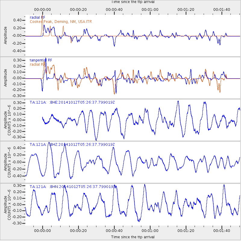
121A Cookes Peak, Deming, NM, USA - Earthquake Result Viewer
*The percent match for this event was below the threshold and hence no stack was calculated.
| Earthquake location: |
Reykjanes Ridge |
| Earthquake latitude/longitude: |
57.4/-33.4 |
| Earthquake time(UTC): |
2014/10/12 (285) 05:17:37 GMT |
| Earthquake Depth: |
16 km |
| Earthquake Magnitude: |
5.3 MW |
| Earthquake Catalog/Contributor: |
ISC/ISC |
|
| Network: |
TA USArray Transportable Network (new EarthScope stations) |
| Station: |
121A Cookes Peak, Deming, NM, USA |
| Lat/Lon: |
32.53 N/107.79 W |
| Elevation: |
1652 m |
|
| Distance: |
55.1 deg |
| Az: |
276.965 deg |
| Baz: |
39.563 deg |
| Ray Param: |
$rayparam |
*The percent match for this event was below the threshold and hence was not used in the summary stack. |
|
| Radial Match: |
63.278965 % |
| Radial Bump: |
400 |
| Transverse Match: |
74.243774 % |
| Transverse Bump: |
339 |
| SOD ConfigId: |
3390531 |
| Insert Time: |
2019-04-14 12:16:22.968 +0000 |
| GWidth: |
2.5 |
| Max Bumps: |
400 |
| Tol: |
0.001 |
|
Signal To Noise
| Channel | StoN | STA | LTA |
| TA:121A: :BHZ:20141012T05:26:37.799019Z | 1.8060482 | 3.879949E-7 | 2.1483088E-7 |
| TA:121A: :BHN:20141012T05:26:37.799019Z | 0.63114524 | 9.911334E-8 | 1.5703729E-7 |
| TA:121A: :BHE:20141012T05:26:37.799019Z | 2.7216287 | 1.9434363E-7 | 7.140711E-8 |
| Arrivals |
| Ps | |
| PpPs | |
| PsPs/PpSs | |


