You are here: Home > Network List > IU - Global Seismograph Network (GSN - IRIS/USGS) Stations List
> Station RSSD Black Hills, South Dakota, USA > Earthquake Result Viewer
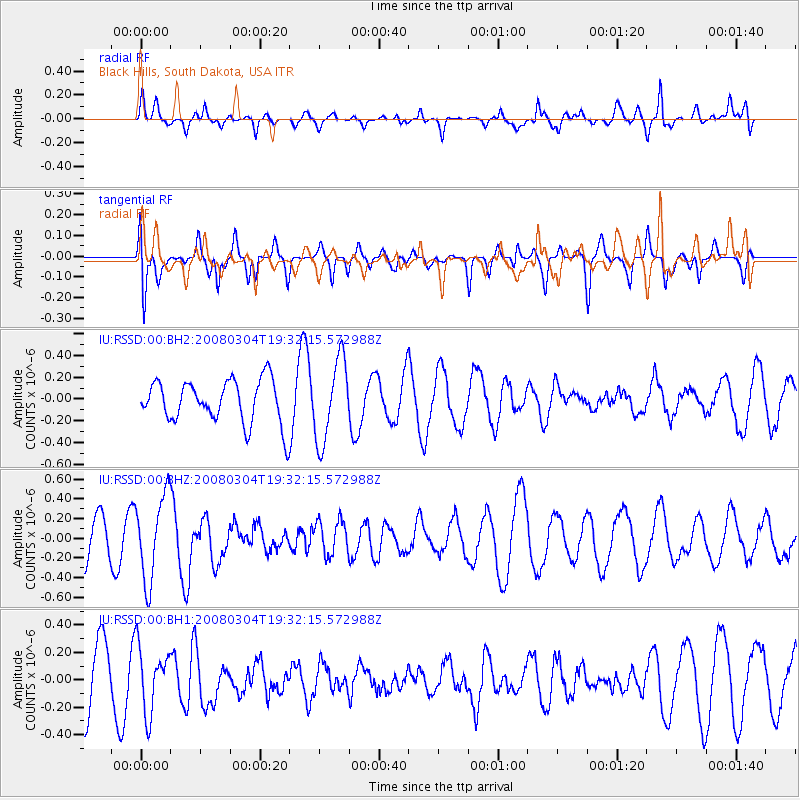
RSSD Black Hills, South Dakota, USA - Earthquake Result Viewer
*The percent match for this event was below the threshold and hence no stack was calculated.
| Earthquake location: |
Andreanof Islands, Aleutian Is. |
| Earthquake latitude/longitude: |
52.2/-173.7 |
| Earthquake time(UTC): |
2008/03/04 (064) 19:24:27 GMT |
| Earthquake Depth: |
10 km |
| Earthquake Magnitude: |
5.5 MW, 5.5 MW |
| Earthquake Catalog/Contributor: |
NEIC PDE/NEIC PDE-M |
|
| Network: |
IU Global Seismograph Network (GSN - IRIS/USGS) |
| Station: |
RSSD Black Hills, South Dakota, USA |
| Lat/Lon: |
44.12 N/104.04 W |
| Elevation: |
2060 m |
|
| Distance: |
45.5 deg |
| Az: |
71.237 deg |
| Baz: |
306.054 deg |
| Ray Param: |
$rayparam |
*The percent match for this event was below the threshold and hence was not used in the summary stack. |
|
| Radial Match: |
61.92178 % |
| Radial Bump: |
400 |
| Transverse Match: |
69.34089 % |
| Transverse Bump: |
381 |
| SOD ConfigId: |
590571 |
| Insert Time: |
2013-09-26 20:39:28.465 +0000 |
| GWidth: |
2.5 |
| Max Bumps: |
400 |
| Tol: |
0.001 |
|
Signal To Noise
| Channel | StoN | STA | LTA |
| IU:RSSD:00:BHZ:20080304T19:32:15.572988Z | 1.9166399 | 4.3016607E-7 | 2.2443761E-7 |
| IU:RSSD:00:BH1:20080304T19:32:15.572988Z | 1.2135375 | 2.3641275E-7 | 1.948129E-7 |
| IU:RSSD:00:BH2:20080304T19:32:15.572988Z | 1.9111377 | 3.7563092E-7 | 1.9654833E-7 |
| Arrivals |
| Ps | |
| PpPs | |
| PsPs/PpSs | |


