You are here: Home > Network List > II - Global Seismograph Network (GSN - IRIS/IDA) Stations List
> Station PALK Pallekele, Sri Lanka > Earthquake Result Viewer
PALK Pallekele, Sri Lanka - Earthquake Result Viewer
| Earthquake location: |
Halmahera, Indonesia |
| Earthquake latitude/longitude: |
2.6/128.2 |
| Earthquake time(UTC): |
2008/03/06 (066) 01:21:59 GMT |
| Earthquake Depth: |
125 km |
| Earthquake Magnitude: |
5.9 MB, 5.8 MW, 5.8 MW |
| Earthquake Catalog/Contributor: |
WHDF/NEIC |
|
| Network: |
II Global Seismograph Network (GSN - IRIS/IDA) |
| Station: |
PALK Pallekele, Sri Lanka |
| Lat/Lon: |
7.27 N/80.70 E |
| Elevation: |
460 m |
|
| Distance: |
47.6 deg |
| Az: |
277.457 deg |
| Baz: |
93.154 deg |
| Ray Param: |
0.06949034 |
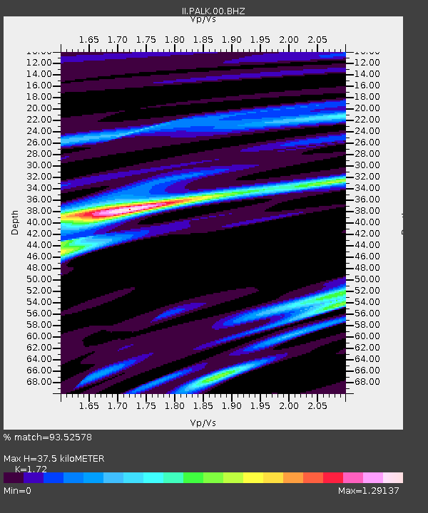
| Estimated Moho Depth: |
37.5 km |
| Estimated Crust Vp/Vs: |
1.72 |
| Assumed Crust Vp: |
6.545 km/s |
| Estimated Crust Vs: |
3.805 km/s |
| Estimated Crust Poisson's Ratio: |
0.24 |
|
| Radial Match: |
93.52578 % |
| Radial Bump: |
354 |
| Transverse Match: |
79.95137 % |
| Transverse Bump: |
400 |
| SOD ConfigId: |
590571 |
| Insert Time: |
2013-09-26 20:41:07.743 +0000 |
| GWidth: |
2.5 |
| Max Bumps: |
400 |
| Tol: |
0.001 |
|
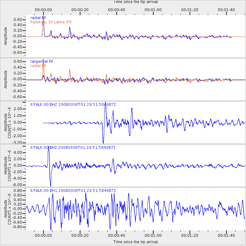
Signal To Noise
| Channel | StoN | STA | LTA |
| II:PALK:00:BHZ:20080306T01:29:51.584987Z | 20.575 | 2.7561732E-6 | 1.3395739E-7 |
| II:PALK:00:BH1:20080306T01:29:51.584987Z | 2.8636918 | 3.417541E-7 | 1.1934038E-7 |
| II:PALK:00:BH2:20080306T01:29:51.584987Z | 16.683634 | 1.4295379E-6 | 8.5685045E-8 |
| Arrivals |
| Ps | 4.4 SECOND |
| PpPs | 15 SECOND |
| PsPs/PpSs | 19 SECOND |


