You are here: Home > Network List > II - Global Seismograph Network (GSN - IRIS/IDA) Stations List
> Station JTS Las Juntas de Abangares, Costa Rica > Earthquake Result Viewer
JTS Las Juntas de Abangares, Costa Rica - Earthquake Result Viewer

| Earthquake location: |
South Of Fiji Islands |
| Earthquake latitude/longitude: |
-22.1/-176.8 |
| Earthquake time(UTC): |
1997/10/14 (287) 09:53:18 GMT |
| Earthquake Depth: |
167 km |
| Earthquake Magnitude: |
6.7 MB, 7.7 UNKNOWN, 7.4 ME |
| Earthquake Catalog/Contributor: |
WHDF/NEIC |
|
| Network: |
II Global Seismograph Network (GSN - IRIS/IDA) |
| Station: |
JTS Las Juntas de Abangares, Costa Rica |
| Lat/Lon: |
10.29 N/84.95 W |
| Elevation: |
340 m |
|
| Distance: |
95.5 deg |
| Az: |
81.164 deg |
| Baz: |
248.619 deg |
| Ray Param: |
0.04064414 |
| Estimated Moho Depth: |
47.0 km |
| Estimated Crust Vp/Vs: |
1.60 |
| Assumed Crust Vp: |
6.597 km/s |
| Estimated Crust Vs: |
4.123 km/s |
| Estimated Crust Poisson's Ratio: |
0.18 |
|
| Radial Match: |
97.873405 % |
| Radial Bump: |
356 |
| Transverse Match: |
94.845634 % |
| Transverse Bump: |
400 |
| SOD ConfigId: |
6273 |
| Insert Time: |
2010-03-01 15:14:24.259 +0000 |
| GWidth: |
2.5 |
| Max Bumps: |
400 |
| Tol: |
0.001 |
|
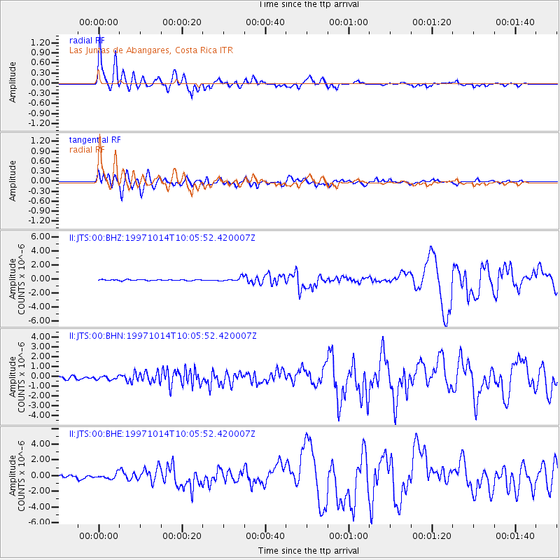
Signal To Noise
| Channel | StoN | STA | LTA |
| II:JTS:00:BHN:19971014T10:05:52.420007Z | 0.99150753 | 1.7719134E-7 | 1.7870902E-7 |
| II:JTS:00:BHE:19971014T10:05:52.420007Z | 2.125879 | 3.420609E-7 | 1.6090327E-7 |
| II:JTS:00:BHZ:19971014T10:05:52.420007Z | 4.385621 | 2.9984557E-7 | 6.837015E-8 |
| Arrivals |
| Ps | 4.4 SECOND |
| PpPs | 18 SECOND |
| PsPs/PpSs | 22 SECOND |


