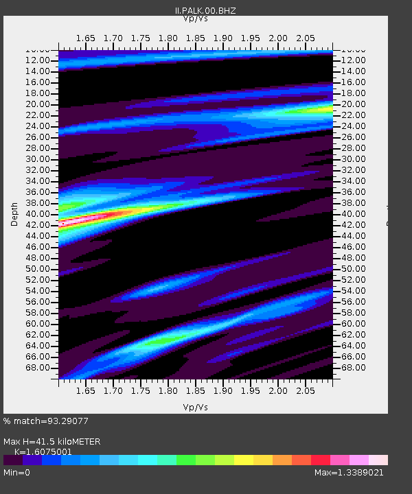
PALK Pallekele, Sri Lanka - Earthquake Result Viewer
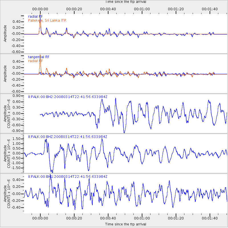
Earthquake location: Bonin Islands, Japan Region
Earthquake latitude/longitude: 27.0/142.6
Earthquake time(UTC): 2008/03/14 (074) 22:32:09 GMT
Earthquake Depth: 11 km
Earthquake Magnitude: 5.7 MB, 5.9 MS, 6.0 MW, 6.0 MW
Earthquake Catalog/Contributor: WHDF/NEIC
Network: II Global Seismograph Network (GSN - IRIS/IDA)
Station: PALK Pallekele, Sri Lanka
Lat/Lon: 7.27 N/80.70 E
Elevation: 460 m
Distance: 61.7 deg
Az: 263.563 deg
Baz: 63.356 deg
Ray Param: 0.06069248
Estimated Moho Depth: 41.5 km
Estimated Crust Vp/Vs: 1.61
Assumed Crust Vp: 6.545 km/s
Estimated Crust Vs: 4.072 km/s
Estimated Crust Poisson's Ratio: 0.18
Radial Match: 93.29077 %
Radial Bump: 319
Transverse Match: 82.92246 %
Transverse Bump: 400
SOD ConfigId: 590571
Insert Time: 2013-09-26 20:56:24.462 +0000
GWidth: 2.5
Max Bumps: 400
Tol: 0.001

Signal To Noise

ChannelStoNSTALTA
II:PALK:00:BHZ:20080314T22:41:56.633984Z7.12122347.133966E-71.0017893E-7
II:PALK:00:BH1:20080314T22:41:56.633984Z2.07161641.8365422E-78.865261E-8
II:PALK:00:BH2:20080314T22:41:56.633984Z5.0359063.1466686E-76.248466E-8
Arrivals
Ps4.1 SECOND
PpPs16 SECOND
PsPs/PpSs20 SECOND